San Pedro del Paraná geodata
San Pedro del Paraná (Itapúa) is a populated place; located in Paraguay in America/Asuncion (GMT-4) time zone. With population of 5,722 people, there are 52 cities with bigger population in this country. Compared to other cities in Paraguay, 84.6% of cities are located further ↑North; 67.9% of cities are located further ←West and 55.6% of cities have lower elevation than San Pedro del Paraná. Note1


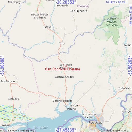
San Pedro del Paraná GPS coordinates[2]
26° 49' 57.648" South, 56° 12' 20.7" West
| Map corner | latitude | longitude |
|---|---|---|
| Upper-left | -26.20353°, | -56.90888° |
| Center: | -26.83268°, | -56.20575° |
| Lower-right: | -27.45835°, | -55.50263° |
| Map W x H: | 139.5×139.5 km | = 86.7×86.7mi |
| max Lat: | -19.91667° ⇑84.6% North |
| San Pedro del Paraná: | -26.83268° |
| min Lat: | ⇓15.4% South -27.38662° |
| min Long | San Pedro del P | max Long |
| -60.78333° | -56.20575° | -54.30694° |
| W 67.9%⇐ | ⇒32.1% E |
Elevation
Elevation of San Pedro del Paraná is 147 m = 482 ft, and this is 22.7 m = 74 ft below average elevation for this country.
| Max E: |
658 m = 2159 ft | 44.4% |
| Avg. | 169.7 m = 557 ft | |
| San Pedro del Paraná | 147 m = 482 ft | |
Min E: |
46 m = 151 ft | 55.6% |
See also: Paraguay elevation on elevation.city.
Geographical zone
San Pedro del Paraná is located in South temperate zone (between Tropic of Capricorn and the Antarctic Circle). Distance of this Southern Tropic circle is 377.6 km =234.6 mi to North.| Distance of | km | miles | from San Pedro del Paraná |
|---|---|---|---|
| Equator | 2983.5 | 1853.9 | to North |
| Tropic Capricorn | 377.6 | 234.6 | to North |
| Antarctic Circle | 4417.7 | 2745 | to South |
| South Pole | 7023.5 | 4364.2 | to South |


Nearby cities:
15 places around San Pedro del Paraná: (largest is in red/bold)
• Alto Verá
63.3 km =39.3 mi,  64°
64°
• Capitán Miranda
57.3 km =35.6 mi,  135°
135°
• Carmen del Paraná
43.6 km =27.1 mi,  173°
173°
• Fram
36.1 km =22.4 mi,  117°
117°
• General Artigas
11.5 km =7.1 mi,  187°
187°
• General Delgado
42.7 km =26.5 mi,  227°
227°
• Hohenau
61.9 km =38.5 mi, 115°
• Jesús
52.3 km =32.5 mi, 118°
• Obligado
61 km =37.9 mi,  111°
111°
• San Cosme y Damián
55.3 km =34.4 mi, 192°
• San Juan del Paraná
57.3 km =35.6 mi,  155°
155°
• San Patricio
62.4 km =38.8 mi,  256°
256°
• Trinidad
52.4 km =32.6 mi,  127°
127°
• Yegros
46.7 km =29 mi,  335°
335°
• Yuty
24.6 km =15.3 mi,  350°
350°
Sources, notices
• [Note1] Compared only with cities in Paraguay existing in our database
• [Src1] Map data: © OpenStreetMap contributors (CC-BY-SA)
• [Src2] Other city data from geonames.org with taken over terms of usage.
• [Src3] Geographical zone / Annual Mean Temperature by Robert A. Rohde @ Wikipedia
