Yuty geodata
Yuty (Caazapá) is a populated place; located in Paraguay in America/Asuncion (GMT-4) time zone. With population of 4,774 people, there are 63 cities with bigger population in this country. Compared to other cities in Paraguay, 81.5% of cities are located further ↑North; 66% of cities are located further ←West and 51.9% of cities have lower elevation than Yuty. Note1


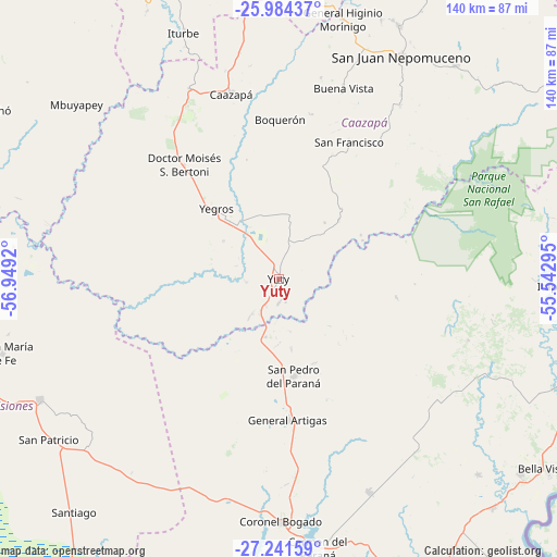
Yuty GPS coordinates[2]
26° 36' 52.956" South, 56° 14' 45.852" West
| Map corner | latitude | longitude |
|---|---|---|
| Upper-left | -25.98437°, | -56.9492° |
| Center: | -26.61471°, | -56.24607° |
| Lower-right: | -27.24159°, | -55.54295° |
| Map W x H: | 139.8×139.8 km | = 86.9×86.9mi |
| max Lat: | -19.91667° ⇑81.5% North |
| Yuty: | -26.61471° |
| min Lat: | ⇓18.5% South -27.38662° |
| min Long | Yuty | max Long |
| -60.78333° | -56.24607° | -54.30694° |
| W 66%⇐ | ⇒34% E |
Elevation
Elevation of Yuty is 143 m = 469 ft, and this is 26.7 m = 88 ft below average elevation for this country.
| Max E: |
658 m = 2159 ft | 48.1% |
| Avg. | 169.7 m = 557 ft | |
| Yuty | 143 m = 469 ft | |
Min E: |
46 m = 151 ft | 51.9% |
See also: Paraguay elevation on elevation.city.
Geographical zone
Yuty is located in South temperate zone (between Tropic of Capricorn and the Antarctic Circle). Distance of this Southern Tropic circle is 353.4 km =219.6 mi to North.| Distance of | km | miles | from Yuty |
|---|---|---|---|
| Equator | 2959.3 | 1838.8 | to North |
| Tropic Capricorn | 353.4 | 219.6 | to North |
| Antarctic Circle | 4441.9 | 2760.1 | to South |
| South Pole | 7047.8 | 4379.3 | to South |


Nearby cities:
15 places around Yuty: (largest is in red/bold)
• Alto Verá
61 km =37.9 mi,  86°
86°
• Buena Vista
50.6 km =31.4 mi,  18°
18°
• Caazapá
48.1 km =29.9 mi,  345°
345°
• Carmen del Paraná
68.2 km =42.4 mi,  172°
172°
• Fram
54.6 km =33.9 mi,  138°
138°
• General Artigas
35.7 km =22.2 mi,  176°
176°
• General Delgado
59.7 km =37.1 mi,  207°
207°
• Itapuá Poty
66.1 km =41.1 mi, 86°
• Iturbe
66.6 km =41.4 mi,  339°
339°
• Maciel
53.1 km =33 mi,  334°
334°
• Mbuyapey
67.3 km =41.8 mi,  310°
310°
• San Juan Nepomuceno
63.7 km =39.6 mi,  28°
28°
• San Pedro del Paraná
24.6 km =15.3 mi, 170°
• Santa Rosa Misiones
67.1 km =41.7 mi,  243°
243°
• Yegros
23.9 km =14.9 mi,  320°
320°
Sources, notices
• [Note1] Compared only with cities in Paraguay existing in our database
• [Src1] Map data: © OpenStreetMap contributors (CC-BY-SA)
• [Src2] Other city data from geonames.org with taken over terms of usage.
• [Src3] Geographical zone / Annual Mean Temperature by Robert A. Rohde @ Wikipedia
