Obligado geodata
Obligado (Itapúa) is a populated place; located in Paraguay in America/Asuncion (GMT-4) time zone. With population of 6,350 people, there are 49 cities with bigger population in this country. Compared to other cities in Paraguay, 89.5% of cities are located further ↑North; 82.7% of cities are located further ←West and 71% of cities have lower elevation than Obligado. Note1


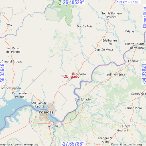
Obligado GPS coordinates[2]
27° 1' 59.988" South, 55° 37' 59.988" West
| Map corner | latitude | longitude |
|---|---|---|
| Upper-left | -26.40529°, | -56.33646° |
| Center: | -27.03333°, | -55.63333° |
| Lower-right: | -27.65788°, | -54.93021° |
| Map W x H: | 139.3×139.3 km | = 86.6×86.6mi |
| max Lat: | -19.91667° ⇑89.5% North |
| Obligado: | -27.03333° |
| min Lat: | ⇓10.5% South -27.38662° |
| min Long | Obligado | max Long |
| -60.78333° | -55.63333° | -54.30694° |
| W 82.7%⇐ | ⇒17.3% E |
Elevation
Elevation of Obligado is 188 m = 617 ft, and this is 18.3 m = 60 ft above average elevation for this country.
| Max E: |
658 m = 2159 ft | 29% |
| Obligado | 188 m 617 ft | |
| Avg. | 169.7 m = 557 ft | |
Min E: |
46 m = 151 ft | 71% |
See also: Paraguay elevation on elevation.city.
Geographical zone
Obligado is located in South temperate zone (between Tropic of Capricorn and the Antarctic Circle). Distance of this Southern Tropic circle is 399.9 km =248.5 mi to North.| Distance of | km | miles | from Obligado |
|---|---|---|---|
| Equator | 3005.8 | 1867.7 | to North |
| Tropic Capricorn | 399.9 | 248.5 | to North |
| Antarctic Circle | 4395.3 | 2731.1 | to South |
| South Pole | 7001.2 | 4350.3 | to South |


Nearby cities:
15 places around Obligado: (largest is in red/bold)
• Alto Verá
50 km =31.1 mi,  0°
0°
• Bella Vista
8.5 km =5.3 mi,  102°
102°
• Cambyretá
38.4 km =23.9 mi,  199°
199°
• Capitán Meza
6.9 km =4.3 mi,  74°
74°
• Capitán Miranda
24.8 km =15.4 mi,  221°
221°
• Carmen del Paraná
55.5 km =34.5 mi,  247°
247°
• Edelira
45.9 km =28.5 mi,  49°
49°
• Encarnación
40.3 km =25 mi,  214°
214°
• Fram
25.4 km =15.8 mi,  282°
282°
• Hohenau
4.5 km =2.8 mi,  191°
191°
• Itapuá Poty
50.6 km =31.4 mi,  5°
5°
• Jesús
11 km =6.8 mi,  256°
256°
• Pirapó
21.2 km =13.2 mi,  24°
24°
• San Juan del Paraná
44.4 km =27.6 mi,  227°
227°
• Trinidad
17.5 km =10.9 mi,  238°
238°
Sources, notices
• [Note1] Compared only with cities in Paraguay existing in our database
• [Src1] Map data: © OpenStreetMap contributors (CC-BY-SA)
• [Src2] Other city data from geonames.org with taken over terms of usage.
• [Src3] Geographical zone / Annual Mean Temperature by Robert A. Rohde @ Wikipedia
