Yegros geodata
Yegros (Caazapá) is a populated place; located in Paraguay in America/Asuncion (GMT-4) time zone. With population of 1,140 people, there are 138 cities with bigger population in this country. Compared to other cities in Paraguay, 77.8% of cities are located further ↑North; 59.9% of cities are located further ←West and 75.9% of cities have higher elevation than Yegros. Note1


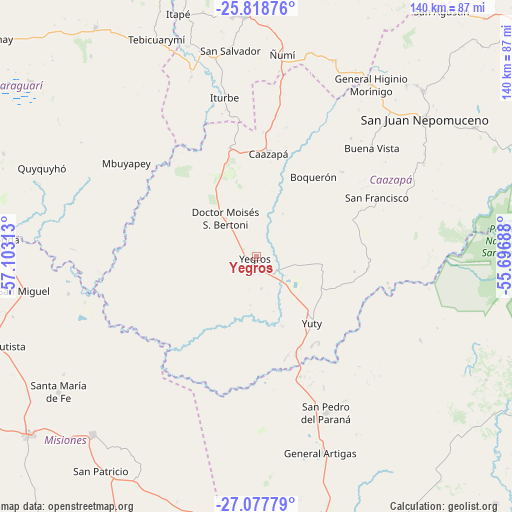
Yegros GPS coordinates[2]
26° 27' 0" South, 56° 24' 0" West
| Map corner | latitude | longitude |
|---|---|---|
| Upper-left | -25.81876°, | -57.10313° |
| Center: | -26.45°, | -56.4° |
| Lower-right: | -27.07779°, | -55.69688° |
| Map W x H: | 140×140 km | = 87×87mi |
| max Lat: | -19.91667° ⇑77.8% North |
| Yegros: | -26.45° |
| min Lat: | ⇓22.2% South -27.38662° |
| min Long | Yegros | max Long |
| -60.78333° | -56.4° | -54.30694° |
| W 59.9%⇐ | ⇒40.1% E |
Elevation
Elevation of Yegros is 115 m = 377 ft, and this is 54.7 m = 179 ft below average elevation for this country.
| Max E: |
658 m = 2159 ft | 75.9% |
| Avg. | 169.7 m = 557 ft | |
| Yegros | 115 m = 377 ft | |
Min E: |
46 m = 151 ft | 24.1% |
See also: Paraguay elevation on elevation.city.
Geographical zone
Yegros is located in South temperate zone (between Tropic of Capricorn and the Antarctic Circle). Distance of this Southern Tropic circle is 335 km =208.2 mi to North.| Distance of | km | miles | from Yegros |
|---|---|---|---|
| Equator | 2941 | 1827.5 | to North |
| Tropic Capricorn | 335 | 208.2 | to North |
| Antarctic Circle | 4460.2 | 2771.4 | to South |
| South Pole | 7066.1 | 4390.7 | to South |


Nearby cities:
15 places around Yegros: (largest is in red/bold)
• Abaí
65.7 km =40.8 mi,  45°
45°
• Buena Vista
43.4 km =27 mi, 46°
• Caazapá
28.4 km =17.6 mi,  6°
6°
• General Artigas
56.8 km =35.3 mi,  161°
161°
• Iturbe
44.7 km =27.8 mi,  349°
349°
• Maciel
30.6 km =19 mi, 346°
• Mbuyapey
43.9 km =27.3 mi,  305°
305°
• Quyquyó
62.9 km =39.1 mi,  292°
292°
• San Juan Nepomuceno
59.4 km =36.9 mi, 50°
• San Miguel
64.9 km =40.3 mi,  265°
265°
• San Pedro del Paraná
46.7 km =29 mi, 155°
• Santa María
64.7 km =40.2 mi,  235°
235°
• Santa Rosa Misiones
66 km =41 mi,  222°
222°
• Yuty
23.9 km =14.9 mi,  140°
140°
• Ñumi
56 km =34.8 mi, 7°
Sources, notices
• [Note1] Compared only with cities in Paraguay existing in our database
• [Src1] Map data: © OpenStreetMap contributors (CC-BY-SA)
• [Src2] Other city data from geonames.org with taken over terms of usage.
• [Src3] Geographical zone / Annual Mean Temperature by Robert A. Rohde @ Wikipedia
