San Miguel geodata
San Miguel (Misiones) is a populated place; located in Paraguay in America/Asuncion (GMT-4) time zone. With population of 1,210 people, there are 135 cities with bigger population in this country. Compared to other cities in Paraguay, 79.6% of cities are located further ↑North; 65.4% of cities are located further →East and 84% of cities have higher elevation than San Miguel. Note1


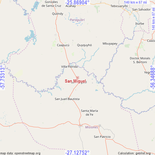
San Miguel GPS coordinates[2]
26° 30' 0" South, 57° 3' 0" West
| Map corner | latitude | longitude |
|---|---|---|
| Upper-left | -25.86904°, | -57.75313° |
| Center: | -26.5°, | -57.05° |
| Lower-right: | -27.12752°, | -56.34688° |
| Map W x H: | 139.9×139.9 km | = 86.9×86.9mi |
| max Lat: | -19.91667° ⇑79.6% North |
| San Miguel: | -26.5° |
| min Lat: | ⇓20.4% South -27.38662° |
| min Long | San Miguel | max Long |
| -60.78333° | -57.05° | -54.30694° |
| W 34.6%⇐ | ⇒65.4% E |
Elevation
Elevation of San Miguel is 96 m = 315 ft, and this is 73.7 m = 242 ft below average elevation for this country.
| Max E: |
658 m = 2159 ft | 84% |
| Avg. | 169.7 m = 557 ft | |
| San Miguel | 96 m = 315 ft | |
Min E: |
46 m = 151 ft | 16% |
See also: Paraguay elevation on elevation.city.
Geographical zone
San Miguel is located in South temperate zone (between Tropic of Capricorn and the Antarctic Circle). Distance of this Southern Tropic circle is 340.6 km =211.6 mi to North.| Distance of | km | miles | from San Miguel |
|---|---|---|---|
| Equator | 2946.5 | 1830.9 | to North |
| Tropic Capricorn | 340.6 | 211.6 | to North |
| Antarctic Circle | 4454.7 | 2768 | to South |
| South Pole | 7060.5 | 4387.2 | to South |


Nearby cities:
15 places around San Miguel: (largest is in red/bold)
• Acahay
65.6 km =40.8 mi,  351°
351°
• Caapucú
32.2 km =20 mi,  335°
335°
• Iturbe
75 km =46.6 mi,  48°
48°
• La Colmena
71.4 km =44.4 mi,  17°
17°
• Maciel
67.5 km =41.9 mi,  58°
58°
• Mbuyapey
42.7 km =26.5 mi,  43°
43°
• Quiindy
61.1 km =38 mi, 342°
• Quyquyó
30.4 km =18.9 mi,  12°
12°
• San Juan Bautista
21.1 km =13.1 mi,  206°
206°
• San Patricio
56.8 km =35.3 mi,  155°
155°
• Santa María
33.6 km =20.9 mi, 159°
• Santa Rosa Misiones
47.5 km =29.5 mi, 155°
• Villa Florida
16.4 km =10.2 mi,  322°
322°
• Ybycuí
53.7 km =33.4 mi,  0°
0°
• Yegros
64.9 km =40.3 mi,  85°
85°
Sources, notices
• [Note1] Compared only with cities in Paraguay existing in our database
• [Src1] Map data: © OpenStreetMap contributors (CC-BY-SA)
• [Src2] Other city data from geonames.org with taken over terms of usage.
• [Src3] Geographical zone / Annual Mean Temperature by Robert A. Rohde @ Wikipedia
