Acahay geodata
Acahay (Paraguarí) is a populated place; located in Paraguay in America/Asuncion (GMT-4) time zone. With population of 3,205 people, there are 80 cities with bigger population in this country. Compared to other cities in Paraguay, 65.4% of cities are located further ↑North; 72.2% of cities are located further →East and 59.3% of cities have lower elevation than Acahay. Note1


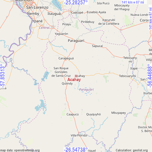
Acahay GPS coordinates[2]
25° 55' 0.012" South, 57° 9' 0" West
| Map corner | latitude | longitude |
|---|---|---|
| Upper-left | -25.28257°, | -57.85313° |
| Center: | -25.91667°, | -57.15° |
| Lower-right: | -26.54738°, | -56.44688° |
| Map W x H: | 140.6×140.6 km | = 87.4×87.4mi |
| max Lat: | -19.91667° ⇑65.4% North |
| Acahay: | -25.91667° |
| min Lat: | ⇓34.6% South -27.38662° |
| min Long | Acahay | max Long |
| -60.78333° | -57.15° | -54.30694° |
| W 27.8%⇐ | ⇒72.2% E |
Elevation
Elevation of Acahay is 155 m = 509 ft, and this is 14.7 m = 48 ft below average elevation for this country.
| Max E: |
658 m = 2159 ft | 40.7% |
| Avg. | 169.7 m = 557 ft | |
| Acahay | 155 m = 509 ft | |
Min E: |
46 m = 151 ft | 59.3% |
See also: Paraguay elevation on elevation.city.
Geographical zone
Acahay is located in South temperate zone (between Tropic of Capricorn and the Antarctic Circle). Distance of this Southern Tropic circle is 275.7 km =171.3 mi to North.| Distance of | km | miles | from Acahay |
|---|---|---|---|
| Equator | 2881.7 | 1790.6 | to North |
| Tropic Capricorn | 275.7 | 171.3 | to North |
| Antarctic Circle | 4519.5 | 2808.3 | to South |
| South Pole | 7125.4 | 4427.5 | to South |


Nearby cities:
15 places around Acahay: (largest is in red/bold)
• Caapucú
35.6 km =22.1 mi,  185°
185°
• Carapeguá
15.4 km =9.6 mi,  327°
327°
• Itá
51.1 km =31.8 mi, 334°
• La Colmena
31.1 km =19.3 mi,  83°
83°
• Nueva Italia
46.4 km =28.8 mi,  317°
317°
• Paraguarí
32.9 km =20.4 mi,  0°
0°
• Pirayú
48.8 km =30.3 mi,  349°
349°
• Piribebuy
51.4 km =31.9 mi,  12°
12°
• Quiindy
10.6 km =6.6 mi,  231°
231°
• Quyquyó
38.9 km =24.2 mi,  154°
154°
• Sapucaí
34.1 km =21.2 mi,  35°
35°
• Valenzuela
45.3 km =28.1 mi, 38°
• Yaguarón
41.7 km =25.9 mi,  341°
341°
• Ybycuí
15 km =9.3 mi,  138°
138°
• Ybytymi
39 km =24.2 mi,  63°
63°
Sources, notices
• [Note1] Compared only with cities in Paraguay existing in our database
• [Src1] Map data: © OpenStreetMap contributors (CC-BY-SA)
• [Src2] Other city data from geonames.org with taken over terms of usage.
• [Src3] Geographical zone / Annual Mean Temperature by Robert A. Rohde @ Wikipedia
