Quyquyó geodata
Quyquyó (Paraguarí) is a populated place; located in Paraguay in America/Asuncion (GMT-4) time zone. With population of 756 people, there are 150 cities with bigger population in this country. Compared to other cities in Paraguay, 74.7% of cities are located further ↑North; 63.6% of cities are located further →East and 59.3% of cities have higher elevation than Quyquyó. Note1


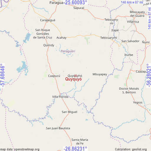
Quyquyó GPS coordinates[2]
26° 13' 59.988" South, 56° 58' 59.988" West
| Map corner | latitude | longitude |
|---|---|---|
| Upper-left | -25.60093°, | -57.68646° |
| Center: | -26.23333°, | -56.98333° |
| Lower-right: | -26.86231°, | -56.28021° |
| Map W x H: | 140.3×140.3 km | = 87.2×87.2mi |
| max Lat: | -19.91667° ⇑74.7% North |
| Quyquyó: | -26.23333° |
| min Lat: | ⇓25.3% South -27.38662° |
| min Long | Quyquyó | max Long |
| -60.78333° | -56.98333° | -54.30694° |
| W 36.4%⇐ | ⇒63.6% E |
Elevation
Elevation of Quyquyó is 129 m = 423 ft, and this is 40.7 m = 134 ft below average elevation for this country.
| Max E: |
658 m = 2159 ft | 59.3% |
| Avg. | 169.7 m = 557 ft | |
| Quyquyó | 129 m = 423 ft | |
Min E: |
46 m = 151 ft | 40.7% |
See also: Paraguay elevation on elevation.city.
Geographical zone
Quyquyó is located in South temperate zone (between Tropic of Capricorn and the Antarctic Circle). Distance of this Southern Tropic circle is 311 km =193.2 mi to North.| Distance of | km | miles | from Quyquyó |
|---|---|---|---|
| Equator | 2916.9 | 1812.5 | to North |
| Tropic Capricorn | 311 | 193.2 | to North |
| Antarctic Circle | 4484.3 | 2786.4 | to South |
| South Pole | 7090.2 | 4405.6 | to South |


Nearby cities:
15 places around Quyquyó: (largest is in red/bold)
• Acahay
38.9 km =24.2 mi,  334°
334°
• Caapucú
19.8 km =12.3 mi,  269°
269°
• Carapeguá
54.3 km =33.7 mi, 332°
• Itapé
56.2 km =34.9 mi,  41°
41°
• Iturbe
53.6 km =33.3 mi,  68°
68°
• La Colmena
41.1 km =25.5 mi,  20°
20°
• Maciel
51.2 km =31.8 mi,  83°
83°
• Mbuyapey
22.6 km =14 mi,  86°
86°
• Quiindy
38 km =23.6 mi,  318°
318°
• San Juan Bautista
51.1 km =31.8 mi,  198°
198°
• San Miguel
30.4 km =18.9 mi,  192°
192°
• Santa María
61.4 km =38.2 mi,  175°
175°
• Villa Florida
23.5 km =14.6 mi,  224°
224°
• Ybycuí
25 km =15.5 mi,  344°
344°
• Ybytymi
55.8 km =34.7 mi, 18°
Sources, notices
• [Note1] Compared only with cities in Paraguay existing in our database
• [Src1] Map data: © OpenStreetMap contributors (CC-BY-SA)
• [Src2] Other city data from geonames.org with taken over terms of usage.
• [Src3] Geographical zone / Annual Mean Temperature by Robert A. Rohde @ Wikipedia
