Encarnación geodata
Encarnación (Itapúa) is a seat of a first-order administrative division; located in Paraguay in America/Asuncion (GMT-4) time zone. With population of 74,983 people, there are 9 cities with bigger population in this country. Compared to other cities in Paraguay, 98.1% of cities are located further ↑North; 75.9% of cities are located further ←West and 74.1% of cities have higher elevation than Encarnación. Note1


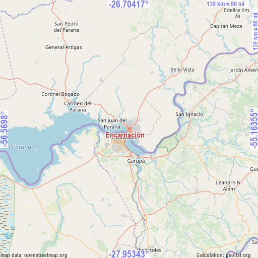
Encarnación GPS coordinates[2]
27° 19' 50.016" South, 55° 52' 0.012" West
| Map corner | latitude | longitude |
|---|---|---|
| Upper-left | -26.70417°, | -56.5698° |
| Center: | -27.33056°, | -55.86667° |
| Lower-right: | -27.95343°, | -55.16355° |
| Map W x H: | 138.9×138.9 km | = 86.3×86.3mi |
| max Lat: | -19.91667° ⇑98.1% North |
| Encarnación: | -27.33056° |
| min Lat: | ⇓1.9% South -27.38662° |
| min Long | Encarnación | max Long |
| -60.78333° | -55.86667° | -54.30694° |
| W 75.9%⇐ | ⇒24.1% E |
Elevation
Elevation of Encarnación is 119 m = 390 ft, and this is 50.7 m = 166 ft below average elevation for this country.
| Max E: |
658 m = 2159 ft | 74.1% |
| Avg. | 169.7 m = 557 ft | |
| Encarnación | 119 m = 390 ft | |
Min E: |
46 m = 151 ft | 25.9% |
See also: Encarnación elevation on elevation.city.
Geographical zone
Encarnación is located in South temperate zone (between Tropic of Capricorn and the Antarctic Circle). Distance of this Southern Tropic circle is 433 km =269.1 mi to North.| Distance of | km | miles | from Encarnación |
|---|---|---|---|
| Equator | 3038.9 | 1888.3 | to North |
| Tropic Capricorn | 433 | 269.1 | to North |
| Antarctic Circle | 4362.3 | 2710.6 | to South |
| South Pole | 6968.2 | 4329.8 | to South |


Nearby cities:
15 places around Encarnación: (largest is in red/bold)
• Bella Vista
44.2 km =27.5 mi,  45°
45°
• Cambyretá
10.9 km =6.8 mi,  106°
106°
• Capitán Meza
45.8 km =28.5 mi,  40°
40°
• Capitán Miranda
15.9 km =9.9 mi,  24°
24°
• Carmen del Paraná
30.7 km =19.1 mi,  293°
293°
• Fram
38.6 km =24 mi,  357°
357°
• General Artigas
56.3 km =35 mi,  321°
321°
• Hohenau
36.2 km =22.5 mi, 37°
• Jesús
33 km =20.5 mi, 22°
• Obligado
40.3 km =25 mi,  34°
34°
• Pirapó
61.3 km =38.1 mi, 31°
• San Cosme y Damián
45.9 km =28.5 mi,  271°
271°
• San Juan del Paraná
10.2 km =6.3 mi, 288°
• San Pedro del Paraná
64.7 km =40.2 mi,  328°
328°
• Trinidad
25.2 km =15.7 mi, 19°
Sources, notices
• [Note1] Compared only with cities in Paraguay existing in our database
• [Src1] Map data: © OpenStreetMap contributors (CC-BY-SA)
• [Src2] Other city data from geonames.org with taken over terms of usage.
• [Src3] Geographical zone / Annual Mean Temperature by Robert A. Rohde @ Wikipedia
