Cambyretá geodata
Cambyretá (Itapúa) is a populated place; located in Paraguay in America/Asuncion (GMT-4) time zone. With population of 822 people, there are 146 cities with bigger population in this country. Compared to other cities in Paraguay, 99.4% of cities are located further ↑North; 78.4% of cities are located further ←West and 77.8% of cities have lower elevation than Cambyretá. Note1


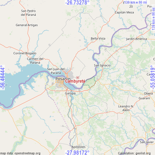
Cambyretá GPS coordinates[2]
27° 21' 32.436" South, 55° 45' 40.716" West
| Map corner | latitude | longitude |
|---|---|---|
| Upper-left | -26.73278°, | -56.46444° |
| Center: | -27.35901°, | -55.76131° |
| Lower-right: | -27.98172°, | -55.05819° |
| Map W x H: | 138.9×138.9 km | = 86.3×86.3mi |
| max Lat: | -19.91667° ⇑99.4% North |
| Cambyretá: | -27.35901° |
| min Lat: | ⇓0.6% South -27.38662° |
| min Long | Cambyretá | max Long |
| -60.78333° | -55.76131° | -54.30694° |
| W 78.4%⇐ | ⇒21.6% E |
Elevation
Elevation of Cambyretá is 207 m = 679 ft, and this is 37.3 m = 122 ft above average elevation for this country.
| Max E: |
658 m = 2159 ft | 22.2% |
| Cambyretá | 207 m 679 ft | |
| Avg. | 169.7 m = 557 ft | |
Min E: |
46 m = 151 ft | 77.8% |
See also: Paraguay elevation on elevation.city.
Geographical zone
Cambyretá is located in South temperate zone (between Tropic of Capricorn and the Antarctic Circle). Distance of this Southern Tropic circle is 436.1 km =271 mi to North.| Distance of | km | miles | from Cambyretá |
|---|---|---|---|
| Equator | 3042 | 1890.2 | to North |
| Tropic Capricorn | 436.1 | 271 | to North |
| Antarctic Circle | 4359.1 | 2708.6 | to South |
| South Pole | 6965 | 4327.8 | to South |


Nearby cities:
15 places around Cambyretá: (largest is in red/bold)
• Bella Vista
40.2 km =25 mi,  31°
31°
• Capitán Meza
42.7 km =26.5 mi, 26°
• Capitán Miranda
18.1 km =11.2 mi,  347°
347°
• Carmen del Paraná
41.5 km =25.8 mi,  291°
291°
• Encarnación
10.9 km =6.8 mi, 286°
• Fram
43.5 km =27 mi,  343°
343°
• General Artigas
65.5 km =40.7 mi,  315°
315°
• Hohenau
33.9 km =21.1 mi,  20°
20°
• Jesús
33.8 km =21 mi,  3°
3°
• Obligado
38.4 km =23.9 mi, 19°
• Pirapó
59.5 km =37 mi, 21°
• San Cosme y Damián
56.4 km =35 mi,  274°
274°
• San Juan del Paraná
21.1 km =13.1 mi, 287°
• San Pedro del Paraná
73.2 km =45.5 mi, 323°
• Trinidad
27 km =16.8 mi,  355°
355°
Sources, notices
• [Note1] Compared only with cities in Paraguay existing in our database
• [Src1] Map data: © OpenStreetMap contributors (CC-BY-SA)
• [Src2] Other city data from geonames.org with taken over terms of usage.
• [Src3] Geographical zone / Annual Mean Temperature by Robert A. Rohde @ Wikipedia
