Capitán Meza geodata
Capitán Meza (Itapúa) is a populated place; located in Paraguay in America/Asuncion (GMT-4) time zone. With population of 963 people, there are 141 cities with bigger population in this country. Compared to other cities in Paraguay, 88.9% of cities are located further ↑North; 84.6% of cities are located further ←West and 73.5% of cities have lower elevation than Capitán Meza. Note1


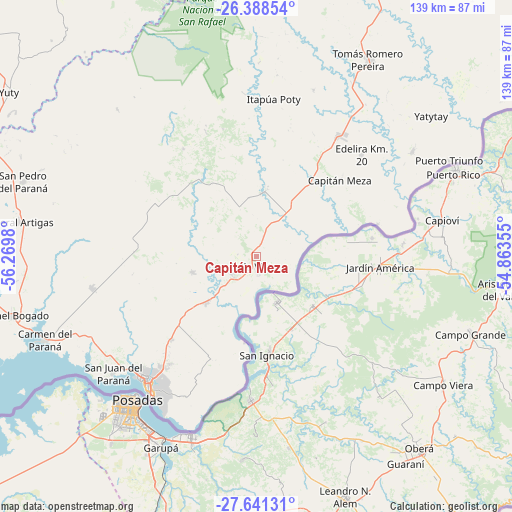
Capitán Meza GPS coordinates[2]
27° 1' 0.012" South, 55° 34' 0.012" West
| Map corner | latitude | longitude |
|---|---|---|
| Upper-left | -26.38854°, | -56.2698° |
| Center: | -27.01667°, | -55.56667° |
| Lower-right: | -27.64131°, | -54.86355° |
| Map W x H: | 139.3×139.3 km | = 86.6×86.6mi |
| max Lat: | -19.91667° ⇑88.9% North |
| Capitán Meza: | -27.01667° |
| min Lat: | ⇓11.1% South -27.38662° |
| min Long | Capitán Meza | max Long |
| -60.78333° | -55.56667° | -54.30694° |
| W 84.6%⇐ | ⇒15.4% E |
Elevation
Elevation of Capitán Meza is 201 m = 659 ft, and this is 31.3 m = 103 ft above average elevation for this country.
| Max E: |
658 m = 2159 ft | 26.5% |
| Capitán Meza | 201 m 659 ft | |
| Avg. | 169.7 m = 557 ft | |
Min E: |
46 m = 151 ft | 73.5% |
See also: Paraguay elevation on elevation.city.
Geographical zone
Capitán Meza is located in South temperate zone (between Tropic of Capricorn and the Antarctic Circle). Distance of this Southern Tropic circle is 398.1 km =247.4 mi to North.| Distance of | km | miles | from Capitán Meza |
|---|---|---|---|
| Equator | 3004 | 1866.6 | to North |
| Tropic Capricorn | 398.1 | 247.4 | to North |
| Antarctic Circle | 4397.2 | 2732.3 | to South |
| South Pole | 7003.1 | 4351.5 | to South |


Nearby cities:
15 places around Capitán Meza: (largest is in red/bold)
• Alto Verá
48.6 km =30.2 mi,  352°
352°
• Bella Vista
4.1 km =2.5 mi,  155°
155°
• Cambyretá
42.7 km =26.5 mi,  206°
206°
• Capitán Miranda
30.8 km =19.1 mi,  228°
228°
• Edelira
39.8 km =24.7 mi,  45°
45°
• Encarnación
45.8 km =28.5 mi,  220°
220°
• Fram
31.6 km =19.6 mi,  276°
276°
• Hohenau
9.8 km =6.1 mi, 230°
• Itapuá Poty
48.5 km =30.1 mi,  358°
358°
• Jesús
17.8 km =11.1 mi,  255°
255°
• Natalio
51.4 km =31.9 mi,  55°
55°
• Obligado
6.9 km =4.3 mi,  254°
254°
• Pirapó
17.6 km =10.9 mi,  7°
7°
• San Juan del Paraná
50.6 km =31.4 mi, 231°
• Trinidad
24.2 km =15 mi,  242°
242°
Sources, notices
• [Note1] Compared only with cities in Paraguay existing in our database
• [Src1] Map data: © OpenStreetMap contributors (CC-BY-SA)
• [Src2] Other city data from geonames.org with taken over terms of usage.
• [Src3] Geographical zone / Annual Mean Temperature by Robert A. Rohde @ Wikipedia
