Abaí geodata
Abaí (Caazapá) is a populated place; located in Paraguay in America/Asuncion (GMT-4) time zone. With population of 3,024 people, there are 82 cities with bigger population in this country. Compared to other cities in Paraguay, 70.4% of cities are located further ↑North; 73.5% of cities are located further ←West and 60.5% of cities have lower elevation than Abaí. Note1


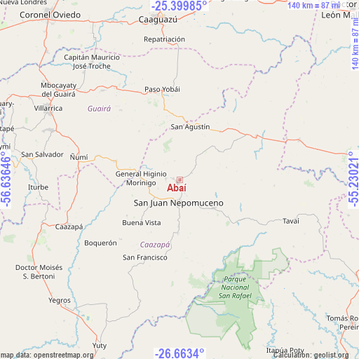
Abaí GPS coordinates[2]
26° 1' 59.988" South, 55° 55' 59.988" West
| Map corner | latitude | longitude |
|---|---|---|
| Upper-left | -25.39985°, | -56.63646° |
| Center: | -26.03333°, | -55.93333° |
| Lower-right: | -26.6634°, | -55.23021° |
| Map W x H: | 140.5×140.5 km | = 87.3×87.3mi |
| max Lat: | -19.91667° ⇑70.4% North |
| Abaí: | -26.03333° |
| min Lat: | ⇓29.6% South -27.38662° |
| min Long | Abaí | max Long |
| -60.78333° | -55.93333° | -54.30694° |
| W 73.5%⇐ | ⇒26.5% E |
Elevation
Elevation of Abaí is 156 m = 512 ft, and this is 13.7 m = 45 ft below average elevation for this country.
| Max E: |
658 m = 2159 ft | 39.5% |
| Avg. | 169.7 m = 557 ft | |
| Abaí | 156 m = 512 ft | |
Min E: |
46 m = 151 ft | 60.5% |
See also: Paraguay elevation on elevation.city.
Geographical zone
Abaí is located in South temperate zone (between Tropic of Capricorn and the Antarctic Circle). Distance of this Southern Tropic circle is 288.7 km =179.4 mi to North.| Distance of | km | miles | from Abaí |
|---|---|---|---|
| Equator | 2894.6 | 1798.6 | to North |
| Tropic Capricorn | 288.7 | 179.4 | to North |
| Antarctic Circle | 4506.5 | 2800.2 | to South |
| South Pole | 7112.4 | 4419.4 | to South |


Nearby cities:
15 places around Abaí: (largest is in red/bold)
• Buena Vista
22.4 km =13.9 mi,  221°
221°
• Caaguazú
63.1 km =39.2 mi,  352°
352°
• Caazapá
47 km =29.2 mi,  247°
247°
• Colonia Mauricio José Troche
62.6 km =38.9 mi,  325°
325°
• General Higinio Morínigo
9.4 km =5.8 mi,  10°
10°
• Independencia
50.7 km =31.5 mi,  318°
318°
• Iturbe
55.1 km =34.2 mi,  267°
267°
• Maciel
56.4 km =35 mi, 252°
• Mbocayaty
60.1 km =37.3 mi,  305°
305°
• Natalicio Talavera
57.7 km =35.9 mi, 320°
• Repatriación
55.6 km =34.5 mi,  358°
358°
• San Juan Nepomuceno
8.8 km =5.5 mi,  183°
183°
• Villarrica
59.3 km =36.8 mi,  302°
302°
• Yegros
65.7 km =40.8 mi,  225°
225°
• Ñumi
40.7 km =25.3 mi,  283°
283°
Sources, notices
• [Note1] Compared only with cities in Paraguay existing in our database
• [Src1] Map data: © OpenStreetMap contributors (CC-BY-SA)
• [Src2] Other city data from geonames.org with taken over terms of usage.
• [Src3] Geographical zone / Annual Mean Temperature by Robert A. Rohde @ Wikipedia
