Caazapá geodata
Caazapá is a seat of a first-order administrative division; located in Paraguay in America/Asuncion (GMT-4) time zone. With population of 23,996 people, there are 21 cities with bigger population in this country. Compared to other cities in Paraguay, 73.5% of cities are located further ↑North; 61.1% of cities are located further ←West and 58% of cities have lower elevation than Caazapá. Note1


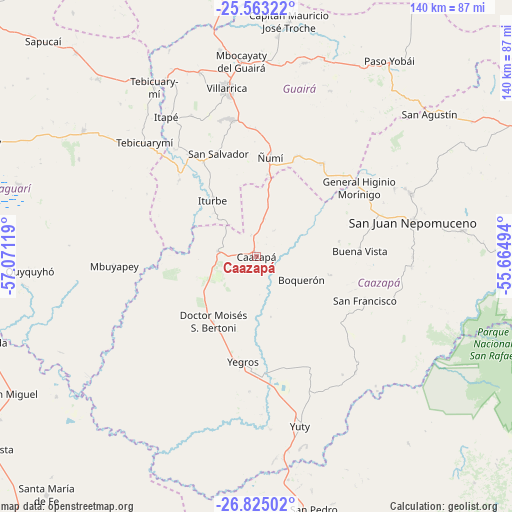
Caazapá GPS coordinates[2]
26° 11' 44.988" South, 56° 22' 5.016" West
| Map corner | latitude | longitude |
|---|---|---|
| Upper-left | -25.56322°, | -57.07119° |
| Center: | -26.19583°, | -56.36806° |
| Lower-right: | -26.82502°, | -55.66494° |
| Map W x H: | 140.3×140.3 km | = 87.2×87.2mi |
| max Lat: | -19.91667° ⇑73.5% North |
| Caazapá: | -26.19583° |
| min Lat: | ⇓26.5% South -27.38662° |
| min Long | Caazapá | max Long |
| -60.78333° | -56.36806° | -54.30694° |
| W 61.1%⇐ | ⇒38.9% E |
Elevation
Elevation of Caazapá is 150 m = 492 ft, and this is 19.7 m = 65 ft below average elevation for this country.
| Max E: |
658 m = 2159 ft | 42% |
| Avg. | 169.7 m = 557 ft | |
| Caazapá | 150 m = 492 ft | |
Min E: |
46 m = 151 ft | 58% |
See also: Paraguay elevation on elevation.city.
Geographical zone
Caazapá is located in South temperate zone (between Tropic of Capricorn and the Antarctic Circle). Distance of this Southern Tropic circle is 306.8 km =190.6 mi to North.| Distance of | km | miles | from Caazapá |
|---|---|---|---|
| Equator | 2912.7 | 1809.9 | to North |
| Tropic Capricorn | 306.8 | 190.6 | to North |
| Antarctic Circle | 4488.5 | 2789 | to South |
| South Pole | 7094.4 | 4408.3 | to South |


Nearby cities:
15 places around Caazapá: (largest is in red/bold)
• Abaí
47 km =29.2 mi,  67°
67°
• Buena Vista
28.6 km =17.8 mi,  87°
87°
• Coronel Martínez
54.6 km =33.9 mi,  332°
332°
• Félix Pérez Cardozo
52.8 km =32.8 mi,  342°
342°
• General Higinio Morínigo
52.7 km =32.7 mi,  58°
58°
• Itapé
45.5 km =28.3 mi, 327°
• Iturbe
19.5 km =12.1 mi,  323°
323°
• Maciel
10.6 km =6.6 mi,  277°
277°
• Mbocayaty
53.2 km =33.1 mi,  354°
354°
• Mbuyapey
39 km =24.2 mi,  266°
266°
• San Juan Nepomuceno
43.9 km =27.3 mi,  77°
77°
• Villarrica
50.1 km =31.1 mi, 352°
• Yegros
28.4 km =17.6 mi,  186°
186°
• Yuty
48.1 km =29.9 mi,  165°
165°
• Ñumi
27.5 km =17.1 mi,  8°
8°
Sources, notices
• [Note1] Compared only with cities in Paraguay existing in our database
• [Src1] Map data: © OpenStreetMap contributors (CC-BY-SA)
• [Src2] Other city data from geonames.org with taken over terms of usage.
• [Src3] Geographical zone / Annual Mean Temperature by Robert A. Rohde @ Wikipedia
