Lima geodata
Lima (San Pedro) is a populated place; located in Paraguay in America/Asuncion (GMT-4) time zone. With population of 10,367 people, there are 32 cities with bigger population in this country. Compared to other cities in Paraguay, 91.4% of cities are located further ↓South; 56.2% of cities are located further ←West and 54.3% of cities have higher elevation than Lima. Note1


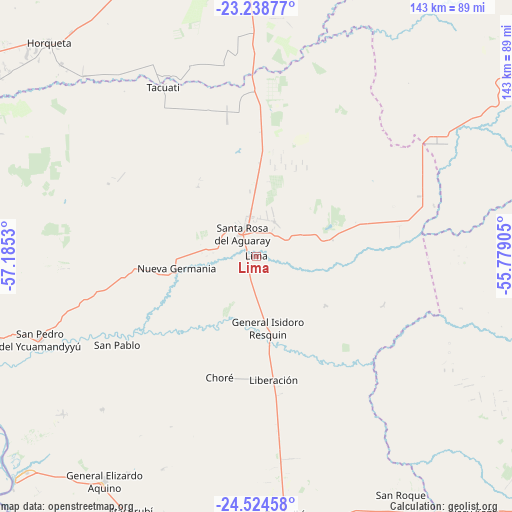
Lima GPS coordinates[2]
23° 52' 59.772" South, 56° 28' 55.812" West
| Map corner | latitude | longitude |
|---|---|---|
| Upper-left | -23.23877°, | -57.1853° |
| Center: | -23.88327°, | -56.48217° |
| Lower-right: | -24.52458°, | -55.77905° |
| Map W x H: | 143×143 km | = 88.9×88.9mi |
| max Lat: | -19.91667° ⇑8.6% North |
| Lima: | -23.88327° |
| min Lat: | ⇓91.4% South -27.38662° |
| min Long | Lima | max Long |
| -60.78333° | -56.48217° | -54.30694° |
| W 56.2%⇐ | ⇒43.8% E |
Elevation
Elevation of Lima is 137 m = 449 ft, and this is 32.7 m = 107 ft below average elevation for this country.
| Max E: |
658 m = 2159 ft | 54.3% |
| Avg. | 169.7 m = 557 ft | |
| Lima | 137 m = 449 ft | |
Min E: |
46 m = 151 ft | 45.7% |
See also: Paraguay elevation on elevation.city.
Geographical zone
Lima is located in South temperate zone (between Tropic of Capricorn and the Antarctic Circle). Distance of this Southern Tropic circle is 49.7 km =30.9 mi to North.| Distance of | km | miles | from Lima |
|---|---|---|---|
| Equator | 2655.6 | 1650.1 | to North |
| Tropic Capricorn | 49.7 | 30.9 | to North |
| Antarctic Circle | 4745.6 | 2948.8 | to South |
| South Pole | 7351.5 | 4568 | to South |


Nearby cities:
15 places around Lima: (largest is in red/bold)
• Antequera
76.5 km =47.5 mi,  252°
252°
• Belén
92 km =57.2 mi,  300°
300°
• Chore
35.2 km =21.9 mi,  196°
196°
• Colonia Nueva Germania
22.5 km =14 mi,  262°
262°
• General Elizardo Aquino
75.4 km =46.9 mi,  214°
214°
• Guayaybi
72.4 km =45 mi,  176°
176°
• Horqueta
84.1 km =52.3 mi,  315°
315°
• Itacurubí del Rosario
80.4 km =50 mi, 205°
• Puerto Rosario
91.3 km =56.7 mi,  227°
227°
• San Pablo de Ycuámandyyú
66.4 km =41.3 mi,  243°
243°
• San Pedro de Ycuamandiyú
65.5 km =40.7 mi, 249°
• Tacuatí
49.3 km =30.6 mi,  347°
347°
• Unión
102.9 km =63.9 mi, 182°
• Veinticinco de Diciembre
91.1 km =56.6 mi, 184°
• Ygatimi
89.2 km =55.4 mi,  107°
107°
Sources, notices
• [Note1] Compared only with cities in Paraguay existing in our database
• [Src1] Map data: © OpenStreetMap contributors (CC-BY-SA)
• [Src2] Other city data from geonames.org with taken over terms of usage.
• [Src3] Geographical zone / Annual Mean Temperature by Robert A. Rohde @ Wikipedia
