Antequera geodata
Antequera (San Pedro) is a populated place; located in Paraguay in America/Asuncion (GMT-4) time zone. With population of 2,701 people, there are 89 cities with bigger population in this country. Compared to other cities in Paraguay, 88.9% of cities are located further ↓South; 74.1% of cities are located further →East and 95.1% of cities have higher elevation than Antequera. Note1


Antequera GPS coordinates[2]
24° 5' 6.936" South, 57° 12' 7.956" West
| Map corner | latitude | longitude |
|---|---|---|
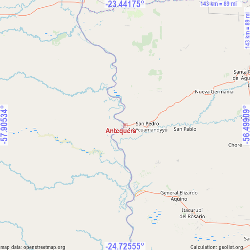
| Upper-left | -23.44175°, | -57.90534° |
| Center: | -24.08526°, | -57.20221° |
| Lower-right: | -24.72555°, | -56.49909° |
| Map W x H: | 142.7×142.7 km | = 88.7×88.7mi |
| max Lat: | -19.91667° ⇑11.1% North |
| Antequera: | -24.08526° |
| min Lat: | ⇓88.9% South -27.38662° |
| min Long | Antequera | max Long |
| -60.78333° | -57.20221° | -54.30694° |
| W 25.9%⇐ | ⇒74.1% E |
Elevation
Elevation of Antequera is 70 m = 230 ft, and this is 99.7 m = 327 ft below average elevation for this country.
| Max E: |
658 m = 2159 ft | 95.1% |
| Avg. | 169.7 m = 557 ft | |
| Antequera | 70 m = 230 ft | |
Min E: |
46 m = 151 ft | 4.9% |
See also: Paraguay elevation on elevation.city.
Geographical zone
Antequera is located in South temperate zone (between Tropic of Capricorn and the Antarctic Circle). Distance of this Southern Tropic circle is 72.1 km =44.8 mi to North.| Distance of | km | miles | from Antequera |
|---|---|---|---|
| Equator | 2678 | 1664 | to North |
| Tropic Capricorn | 72.1 | 44.8 | to North |
| Antarctic Circle | 4723.1 | 2934.8 | to South |
| South Pole | 7329 | 4554 | to South |


Nearby cities:
15 places around Antequera: (largest is in red/bold)
• Belén
69.1 km =42.9 mi,  354°
354°
• Benjamín Aceval
104.7 km =65.1 mi,  200°
200°
• Chore
63.9 km =39.7 mi,  100°
100°
• Colonia Nueva Germania
54.5 km =33.9 mi,  69°
69°
• Concepción
79.7 km =49.5 mi,  342°
342°
• General Elizardo Aquino
50.3 km =31.3 mi,  142°
142°
• Guayaybi
92.5 km =57.5 mi,  122°
122°
• Horqueta
83.8 km =52.1 mi,  9°
9°
• Itacurubí del Rosario
63.1 km =39.2 mi, 142°
• Lima
76.5 km =47.5 mi, 72°
• Puerto Rosario
40 km =24.9 mi,  171°
171°
• San Pablo de Ycuámandyyú
15.5 km =9.6 mi, 117°
• San Pedro de Ycuamandiyú
11.6 km =7.2 mi,  90°
90°
• Tacuatí
94.6 km =58.8 mi,  41°
41°
• Veinticinco de Diciembre
95 km =59 mi, 135°
Sources, notices
• [Note1] Compared only with cities in Paraguay existing in our database
• [Src1] Map data: © OpenStreetMap contributors (CC-BY-SA)
• [Src2] Other city data from geonames.org with taken over terms of usage.
• [Src3] Geographical zone / Annual Mean Temperature by Robert A. Rohde @ Wikipedia
