Tobatí geodata
Tobatí (Cordillera) is a populated place; located in Paraguay in America/Asuncion (GMT-4) time zone. With population of 9,952 people, there are 35 cities with bigger population in this country. Compared to other cities in Paraguay, 67.9% of cities are located further ↓South; 67.3% of cities are located further →East and 63.6% of cities have higher elevation than Tobatí. Note1


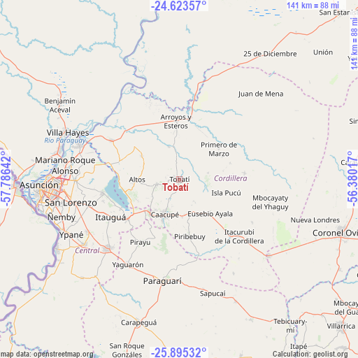
Tobatí GPS coordinates[2]
25° 15' 39.996" South, 57° 4' 59.844" West
| Map corner | latitude | longitude |
|---|---|---|
| Upper-left | -24.62357°, | -57.78642° |
| Center: | -25.26111°, | -57.08329° |
| Lower-right: | -25.89532°, | -56.38017° |
| Map W x H: | 141.4×141.4 km | = 87.9×87.9mi |
| max Lat: | -19.91667° ⇑32.1% North |
| Tobatí: | -25.26111° |
| min Lat: | ⇓67.9% South -27.38662° |
| min Long | Tobatí | max Long |
| -60.78333° | -57.08329° | -54.30694° |
| W 32.7%⇐ | ⇒67.3% E |
Elevation
Elevation of Tobatí is 125 m = 410 ft, and this is 44.7 m = 147 ft below average elevation for this country.
| Max E: |
658 m = 2159 ft | 63.6% |
| Avg. | 169.7 m = 557 ft | |
| Tobatí | 125 m = 410 ft | |
Min E: |
46 m = 151 ft | 36.4% |
See also: Paraguay elevation on elevation.city.
Geographical zone
Tobatí is located in South temperate zone (between Tropic of Capricorn and the Antarctic Circle). Distance of this Southern Tropic circle is 202.9 km =126.1 mi to North.| Distance of | km | miles | from Tobatí |
|---|---|---|---|
| Equator | 2808.8 | 1745.3 | to North |
| Tropic Capricorn | 202.9 | 126.1 | to North |
| Antarctic Circle | 4592.4 | 2853.6 | to South |
| South Pole | 7198.3 | 4472.8 | to South |


Nearby cities:
15 places around Tobatí: (largest is in red/bold)
• Altos
17.2 km =10.7 mi,  269°
269°
• Areguá
30.8 km =19.1 mi,  259°
259°
• Arroyos y Esteros
23 km =14.3 mi,  356°
356°
• Atyrá
9.1 km =5.7 mi, 257°
• Caacupé
15.1 km =9.4 mi,  203°
203°
• Caraguatay
25.9 km =16.1 mi,  84°
84°
• Emboscada
29.5 km =18.3 mi,  294°
294°
• Eusebio Ayala
18.3 km =11.4 mi,  137°
137°
• Isla Pucú
19.2 km =11.9 mi,  105°
105°
• Nueva Colombia
28.2 km =17.5 mi, 287°
• Pirayú
29.1 km =18.1 mi,  211°
211°
• Piribebuy
23 km =14.3 mi,  169°
169°
• Primero de Marzo
19.7 km =12.2 mi,  52°
52°
• San Bernardino
22.1 km =13.7 mi, 255°
• Ypacarai
26.3 km =16.3 mi,  231°
231°
Sources, notices
• [Note1] Compared only with cities in Paraguay existing in our database
• [Src1] Map data: © OpenStreetMap contributors (CC-BY-SA)
• [Src2] Other city data from geonames.org with taken over terms of usage.
• [Src3] Geographical zone / Annual Mean Temperature by Robert A. Rohde @ Wikipedia
