Eusebio Ayala geodata
Eusebio Ayala (Cordillera) is a populated place; located in Paraguay in America/Asuncion (GMT-4) time zone. With population of 8,253 people, there are 40 cities with bigger population in this country. Compared to other cities in Paraguay, 59.3% of cities are located further ↓South; 63% of cities are located further →East and 59.3% of cities have lower elevation than Eusebio Ayala. Note1


Eusebio Ayala GPS coordinates[2]
25° 22' 57.936" South, 56° 57' 39.168" West
| Map corner | latitude | longitude |
|---|---|---|
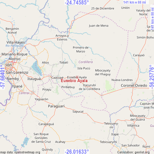
| Upper-left | -24.74585°, | -57.66401° |
| Center: | -25.38276°, | -56.96088° |
| Lower-right: | -26.01633°, | -56.25776° |
| Map W x H: | 141.3×141.3 km | = 87.8×87.8mi |
| max Lat: | -19.91667° ⇑40.7% North |
| Eusebio Ayala: | -25.38276° |
| min Lat: | ⇓59.3% South -27.38662° |
| min Long | Eusebio Ayala | max Long |
| -60.78333° | -56.96088° | -54.30694° |
| W 37%⇐ | ⇒63% E |
Elevation
Elevation of Eusebio Ayala is 155 m = 509 ft, and this is 14.7 m = 48 ft below average elevation for this country.
| Max E: |
658 m = 2159 ft | 40.7% |
| Avg. | 169.7 m = 557 ft | |
| Eusebio Ayala | 155 m = 509 ft | |
Min E: |
46 m = 151 ft | 59.3% |
See also: Paraguay elevation on elevation.city.
Geographical zone
Eusebio Ayala is located in South temperate zone (between Tropic of Capricorn and the Antarctic Circle). Distance of this Southern Tropic circle is 216.4 km =134.5 mi to North.| Distance of | km | miles | from Eusebio Ayala |
|---|---|---|---|
| Equator | 2822.3 | 1753.7 | to North |
| Tropic Capricorn | 216.4 | 134.5 | to North |
| Antarctic Circle | 4578.9 | 2845.2 | to South |
| South Pole | 7184.8 | 4464.4 | to South |


Nearby cities:
15 places around Eusebio Ayala: (largest is in red/bold)
• Altos
32.4 km =20.1 mi,  294°
294°
• Atyrá
24.2 km =15 mi,  298°
298°
• Caacupé
18.2 km =11.3 mi,  268°
268°
• Caraguatay
20.9 km =13 mi,  39°
39°
• Isla Pucú
10.3 km =6.4 mi, 36°
• Itacurubí de la Cordillera
13.9 km =8.6 mi,  129°
129°
• Paraguarí
32.4 km =20.1 mi,  215°
215°
• Pirayú
29.7 km =18.5 mi,  247°
247°
• Piribebuy
12.2 km =7.6 mi, 221°
• Primero de Marzo
25.8 km =16 mi,  7°
7°
• San José
28.3 km =17.6 mi, 126°
• Santa Elena
16.8 km =10.4 mi,  101°
101°
• Sapucaí
31.6 km =19.6 mi,  178°
178°
• Tobatí
18.3 km =11.4 mi,  317°
317°
• Valenzuela
25.4 km =15.8 mi,  159°
159°
Sources, notices
• [Note1] Compared only with cities in Paraguay existing in our database
• [Src1] Map data: © OpenStreetMap contributors (CC-BY-SA)
• [Src2] Other city data from geonames.org with taken over terms of usage.
• [Src3] Geographical zone / Annual Mean Temperature by Robert A. Rohde @ Wikipedia
