Trifeşti geodata
Trifeşti (Iaşi) is a seat of a second-order administrative division; located in Romania in Europe/Bucharest (GMT+3) time zone. With population of 5,232 people, there are 712 cities with bigger population in this country. Compared to other cities in Romania, 89.8% of cities are located further ↓South; 91% of cities are located further ←West and 92.9% of cities have higher elevation than Trifeşti. Note1


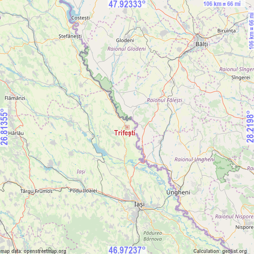
Trifeşti GPS coordinates[2]
47° 27' 0" North, 27° 31' 0.012" East
| Map corner | latitude | longitude |
|---|---|---|
| Upper-left | 47.92333°, | 26.81355° |
| Center: | 47.45°, | 27.51667° |
| Lower-right: | 46.97237°, | 28.2198° |
| Map W x H: | 105.7×105.7 km | = 65.7×65.7mi |
| max Lat: | 48.23793° ⇑10.2% North |
| Trifeşti: | 47.45° |
| min Lat: | ⇓89.8% South 43.65638° |
| min Long | Trifeşti | max Long |
| 20.31667° | 27.51667° | 29.65403° |
| W 91%⇐ | ⇒9% E |
Elevation
Elevation of Trifeşti is 44 m = 144 ft, and this is 210.9 m = 692 ft below average elevation for this country.
| Max E: |
1278 m = 4193 ft | 92.9% |
| Avg. | 254.9 m = 836 ft | |
| Trifeşti | 44 m = 144 ft | |
Min E: |
-2 m = -7 ft | 7.1% |
See also: Romania elevation on elevation.city.
Geographical zone
Trifeşti is located in North temperate zone (between Tropic of Cancer and the Arctic Circle). Distance of this North polar circle is 2125.2 km =1320.5 mi to North.| Distance of | km | miles | from Trifeşti |
|---|---|---|---|
| North Pole | 4731.1 | 2939.8 | to North |
| Arctic Circle | 2125.2 | 1320.5 | to North |
| Tropic Cancer | 2670 | 1659.1 | to South |
| Equator | 5275.9 | 3278.3 | to South |


Nearby cities:
15 places around Trifeşti: (largest is in red/bold)
• Bivolari
11.2 km =7 mi,  325°
325°
• Borșa
12 km =7.5 mi,  251°
251°
• Bălteni
5.2 km =3.2 mi,  192°
192°
• Cârniceni
12.3 km =7.6 mi,  184°
184°
• Hermeziu
2.8 km =1.7 mi,  103°
103°
• Mihail Kogălniceanu
13.8 km =8.6 mi,  213°
213°
• Perieni
7.9 km =4.9 mi,  203°
203°
• Probota
7.5 km =4.7 mi, 189°
• Roșcani
8.8 km =5.5 mi,  274°
274°
• Rădeni
6.5 km =4 mi, 249°
• Spineni
15.5 km =9.6 mi,  286°
286°
• Tabăra
15.9 km =9.9 mi, 330°
• Vlădeni
14.3 km =8.9 mi, 254°
• Zaboloteni
3.2 km =2 mi, 333°
• Ţigănaşi
13.5 km =8.4 mi, 196°
Sources, notices
• [Note1] Compared only with cities in Romania existing in our database
• [Src1] Map data: © OpenStreetMap contributors (CC-BY-SA)
• [Src2] Other city data from geonames.org with taken over terms of usage.
• [Src3] Geographical zone / Annual Mean Temperature by Robert A. Rohde @ Wikipedia
