Tărlungeni geodata
Tărlungeni (Braşov) is a seat of a second-order administrative division; located in Romania in Europe/Bucharest (GMT+3) time zone. With population of 7,219 people, there are 376 cities with bigger population in this country. Compared to other cities in Romania, 53.2% of cities are located further ↑North; 58.1% of cities are located further ←West and 95.1% of cities have lower elevation than Tărlungeni. Note1


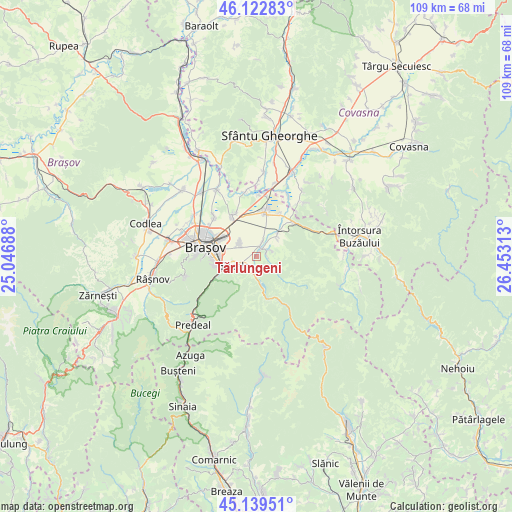
Tărlungeni GPS coordinates[2]
45° 37' 59.988" North, 25° 45' 0" East
| Map corner | latitude | longitude |
|---|---|---|
| Upper-left | 46.12283°, | 25.04688° |
| Center: | 45.63333°, | 25.75° |
| Lower-right: | 45.13951°, | 26.45313° |
| Map W x H: | 109.3×109.3 km | = 67.9×67.9mi |
| max Lat: | 48.23793° ⇑53.2% North |
| Tărlungeni: | 45.63333° |
| min Lat: | ⇓46.8% South 43.65638° |
| min Long | Tărlungeni | max Long |
| 20.31667° | 25.75° | 29.65403° |
| W 58.1%⇐ | ⇒41.9% E |
Elevation
Elevation of Tărlungeni is 632 m = 2073 ft, and this is 377.1 m = 1237 ft above average elevation for this country.
| Max E: |
1278 m = 4193 ft | 4.9% |
| Tărlungeni | 632 m 2073 ft | |
| Avg. | 254.9 m = 836 ft | |
Min E: |
-2 m = -7 ft | 95.1% |
See also: Romania elevation on elevation.city.
Geographical zone
Tărlungeni is located in North temperate zone (between Tropic of Cancer and the Arctic Circle). Distance of this North polar circle is 2327.2 km =1446.1 mi to North.| Distance of | km | miles | from Tărlungeni |
|---|---|---|---|
| North Pole | 4933.1 | 3065.3 | to North |
| Arctic Circle | 2327.2 | 1446.1 | to North |
| Tropic Cancer | 2468 | 1533.5 | to South |
| Equator | 5074 | 3152.8 | to South |


Nearby cities:
15 places around Tărlungeni: (largest is in red/bold)
• Braşov
11.3 km =7 mi,  278°
278°
• Budila
5.4 km =3.4 mi,  46°
46°
• Dobolii de Jos
16.6 km =10.3 mi,  2°
2°
• Dobârlău
15.2 km =9.4 mi,  42°
42°
• Dălghiu
14.3 km =8.9 mi,  118°
118°
• Hărman
10.6 km =6.6 mi,  330°
330°
• Podu Oltului
14.3 km =8.9 mi,  351°
351°
• Prejmer
9.4 km =5.8 mi,  7°
7°
• Purcăreni
3.5 km =2.2 mi,  68°
68°
• Sânpetru
12.3 km =7.6 mi,  314°
314°
• Săcele
3.5 km =2.2 mi,  238°
238°
• Teliu
11 km =6.8 mi, 48°
• Timișu de Jos
11.5 km =7.1 mi, 239°
• Tunelu-Teliu
10.7 km =6.6 mi, 46°
• Zizin
2.3 km =1.4 mi,  79°
79°
Sources, notices
• [Note1] Compared only with cities in Romania existing in our database
• [Src1] Map data: © OpenStreetMap contributors (CC-BY-SA)
• [Src2] Other city data from geonames.org with taken over terms of usage.
• [Src3] Geographical zone / Annual Mean Temperature by Robert A. Rohde @ Wikipedia
