Purcăreni geodata
Purcăreni (Braşov) is a populated place; located in Romania in Europe/Bucharest (GMT+3) time zone. With population of 1,484 people, there are 3203 cities with bigger population in this country. Compared to other cities in Romania, 52.9% of cities are located further ↑North; 59% of cities are located further ←West and 94.2% of cities have lower elevation than Purcăreni. Note1


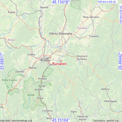
Purcăreni GPS coordinates[2]
45° 38' 41.136" North, 25° 47' 28.644" East
| Map corner | latitude | longitude |
|---|---|---|
| Upper-left | 46.13416°, | 25.08817° |
| Center: | 45.64476°, | 25.79129° |
| Lower-right: | 45.15104°, | 26.49442° |
| Map W x H: | 109.3×109.3 km | = 67.9×67.9mi |
| max Lat: | 48.23793° ⇑52.9% North |
| Purcăreni: | 45.64476° |
| min Lat: | ⇓47.1% South 43.65638° |
| min Long | Purcăreni | max Long |
| 20.31667° | 25.79129° | 29.65403° |
| W 59%⇐ | ⇒41% E |
Elevation
Elevation of Purcăreni is 603 m = 1978 ft, and this is 348.1 m = 1142 ft above average elevation for this country.
| Max E: |
1278 m = 4193 ft | 5.8% |
| Purcăreni | 603 m 1978 ft | |
| Avg. | 254.9 m = 836 ft | |
Min E: |
-2 m = -7 ft | 94.2% |
See also: Romania elevation on elevation.city.
Geographical zone
Purcăreni is located in North temperate zone (between Tropic of Cancer and the Arctic Circle). Distance of this North polar circle is 2326 km =1445.3 mi to North.| Distance of | km | miles | from Purcăreni |
|---|---|---|---|
| North Pole | 4931.8 | 3064.5 | to North |
| Arctic Circle | 2326 | 1445.3 | to North |
| Tropic Cancer | 2469.3 | 1534.4 | to South |
| Equator | 5075.2 | 3153.6 | to South |


Nearby cities:
15 places around Purcăreni: (largest is in red/bold)
• Braşov
14.4 km =8.9 mi,  271°
271°
• Budila
2.5 km =1.6 mi,  15°
15°
• Chichiş
15.4 km =9.6 mi,  2°
2°
• Dobârlău
12.2 km =7.6 mi,  35°
35°
• Dălghiu
12.4 km =7.7 mi,  131°
131°
• Hărman
11.6 km =7.2 mi,  313°
313°
• Podu Oltului
13.9 km =8.6 mi,  337°
337°
• Prejmer
8.2 km =5.1 mi,  346°
346°
• Sânpetru
14.1 km =8.8 mi,  301°
301°
• Săcele
7 km =4.3 mi,  243°
243°
• Teliu
7.8 km =4.8 mi, 40°
• Timișu de Jos
14.9 km =9.3 mi, 241°
• Tunelu-Teliu
7.7 km =4.8 mi, 36°
• Tărlungeni
3.5 km =2.2 mi,  248°
248°
• Zizin
1.3 km =0.8 mi,  227°
227°
Sources, notices
• [Note1] Compared only with cities in Romania existing in our database
• [Src1] Map data: © OpenStreetMap contributors (CC-BY-SA)
• [Src2] Other city data from geonames.org with taken over terms of usage.
• [Src3] Geographical zone / Annual Mean Temperature by Robert A. Rohde @ Wikipedia
