Câmpulung geodata
Câmpulung (Arges) is a seat of a second-order administrative division; located in Romania in Europe/Bucharest (GMT+3) time zone. In our database, there are 7076 cities with bigger population. Compared to other cities in Romania, 59.9% of cities are located further ↑North; 52% of cities are located further →East and 93.9% of cities have lower elevation than Câmpulung. Note1


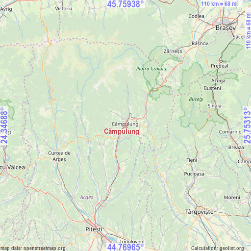
Câmpulung GPS coordinates[2]
45° 16' 0.012" North, 25° 3' 0" East
| Map corner | latitude | longitude |
|---|---|---|
| Upper-left | 45.75938°, | 24.34688° |
| Center: | 45.26667°, | 25.05° |
| Lower-right: | 44.76965°, | 25.75313° |
| Map W x H: | 110×110 km | = 68.4×68.4mi |
| max Lat: | 48.23793° ⇑59.9% North |
| Câmpulung: | 45.26667° |
| min Lat: | ⇓40.1% South 43.65638° |
| min Long | Câmpulung | max Long |
| 20.31667° | 25.05° | 29.65403° |
| W 48%⇐ | ⇒52% E |
Elevation
Elevation of Câmpulung is 593 m = 1946 ft, and this is 338.1 m = 1109 ft above average elevation for this country.
| Max E: |
1278 m = 4193 ft | 6.1% |
| Câmpulung | 593 m 1946 ft | |
| Avg. | 254.9 m = 836 ft | |
Min E: |
-2 m = -7 ft | 93.9% |
See also: Romania elevation on elevation.city.
Geographical zone
Câmpulung is located in North temperate zone (between Tropic of Cancer and the Arctic Circle). Distance of this North polar circle is 2368 km =1471.4 mi to North.| Distance of | km | miles | from Câmpulung |
|---|---|---|---|
| North Pole | 4973.9 | 3090.6 | to North |
| Arctic Circle | 2368 | 1471.4 | to North |
| Tropic Cancer | 2427.3 | 1508.3 | to South |
| Equator | 5033.2 | 3127.5 | to South |


Nearby cities:
15 places around Câmpulung: (largest is in red/bold)
• Albeşti
5.8 km =3.6 mi,  325°
325°
• Bughea de Jos
3.9 km =2.4 mi,  270°
270°
• Bughea de Sus
3.7 km =2.3 mi,  338°
338°
• Godeni
6.4 km =4 mi,  234°
234°
• Groșani
4.4 km =2.7 mi,  196°
196°
• Jugur
8.7 km =5.4 mi,  161°
161°
• Lereşti
7.5 km =4.7 mi,  9°
9°
• Mățău
4.3 km =2.7 mi,  143°
143°
• Nămăești
6.5 km =4 mi,  49°
49°
• Piatra
8.2 km =5.1 mi,  81°
81°
• Poienari
5.6 km =3.5 mi,  180°
180°
• Schitu-Goleşti
8.4 km =5.2 mi,  207°
207°
• Suslănești
6.3 km =3.9 mi,  118°
118°
• Valea Mare Pravăț
4.3 km =2.7 mi, 50°
• Voinești
4.1 km =2.5 mi,  25°
25°
Sources, notices
• [Note1] Compared only with cities in Romania existing in our database
• [Src1] Map data: © OpenStreetMap contributors (CC-BY-SA)
• [Src2] Other city data from geonames.org with taken over terms of usage.
• [Src3] Geographical zone / Annual Mean Temperature by Robert A. Rohde @ Wikipedia
