Mihalţ geodata
Mihalţ (Alba) is a seat of a second-order administrative division; located in Romania in Europe/Bucharest (GMT+3) time zone. With population of 3,601 people, there are 1375 cities with bigger population in this country. Compared to other cities in Romania, 58.4% of cities are located further ↓South; 73.7% of cities are located further →East and 73.9% of cities have lower elevation than Mihalţ. Note1


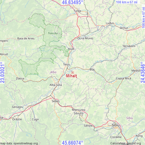
Mihalţ GPS coordinates[2]
46° 9' 0" North, 23° 43' 59.988" East
| Map corner | latitude | longitude |
|---|---|---|
| Upper-left | 46.63495°, | 23.03021° |
| Center: | 46.15°, | 23.73333° |
| Lower-right: | 45.66074°, | 24.43646° |
| Map W x H: | 108.3×108.3 km | = 67.3×67.3mi |
| max Lat: | 48.23793° ⇑41.6% North |
| Mihalţ: | 46.15° |
| min Lat: | ⇓58.4% South 43.65638° |
| min Long | Mihalţ | max Long |
| 20.31667° | 23.73333° | 29.65403° |
| W 26.3%⇐ | ⇒73.7% E |
Elevation
Elevation of Mihalţ is 345 m = 1132 ft, and this is 90.1 m = 296 ft above average elevation for this country.
| Max E: |
1278 m = 4193 ft | 26.1% |
| Mihalţ | 345 m 1132 ft | |
| Avg. | 254.9 m = 836 ft | |
Min E: |
-2 m = -7 ft | 73.9% |
See also: Romania elevation on elevation.city.
Geographical zone
Mihalţ is located in North temperate zone (between Tropic of Cancer and the Arctic Circle). Distance of this North polar circle is 2269.8 km =1410.4 mi to North.| Distance of | km | miles | from Mihalţ |
|---|---|---|---|
| North Pole | 4875.7 | 3029.6 | to North |
| Arctic Circle | 2269.8 | 1410.4 | to North |
| Tropic Cancer | 2525.5 | 1569.3 | to South |
| Equator | 5131.4 | 3188.5 | to South |


Nearby cities:
15 places around Mihalţ: (largest is in red/bold)
• Berghin
8 km =5 mi,  177°
177°
• Bucerdea-Grânoasă
9.5 km =5.9 mi,  54°
54°
• Cistei
4.4 km =2.7 mi,  21°
21°
• Crăciunelu de Jos
8.5 km =5.3 mi,  64°
64°
• Galda de Jos
9.7 km =6 mi,  292°
292°
• Henig
4.9 km =3 mi, 182°
• Obreja
3.7 km =2.3 mi,  42°
42°
• Ohaba
10 km =6.2 mi,  157°
157°
• Oiejdea
7.7 km =4.8 mi,  276°
276°
• Stremţ
10.7 km =6.6 mi,  313°
313°
• Sântimbru
6.7 km =4.2 mi,  253°
253°
• Teiuş
6.8 km =4.2 mi,  325°
325°
• Tiur
12.1 km =7.5 mi,  84°
84°
• Totoi
7 km =4.3 mi,  236°
236°
• Tău
12.2 km =7.6 mi,  136°
136°
Sources, notices
• [Note1] Compared only with cities in Romania existing in our database
• [Src1] Map data: © OpenStreetMap contributors (CC-BY-SA)
• [Src2] Other city data from geonames.org with taken over terms of usage.
• [Src3] Geographical zone / Annual Mean Temperature by Robert A. Rohde @ Wikipedia
