Izvoarele geodata
Izvoarele (Olt) is a seat of a second-order administrative division; located in Romania in Europe/Bucharest (GMT+3) time zone. With population of 3,792 people, there are 1269 cities with bigger population in this country. Compared to other cities in Romania, 91.7% of cities are located further ↑North; 60.2% of cities are located further →East and 67% of cities have higher elevation than Izvoarele. Note1


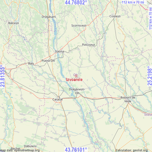
Izvoarele GPS coordinates[2]
44° 16' 0.012" North, 24° 31' 0.012" East
| Map corner | latitude | longitude |
|---|---|---|
| Upper-left | 44.76802°, | 23.81355° |
| Center: | 44.26667°, | 24.51667° |
| Lower-right: | 43.76101°, | 25.2198° |
| Map W x H: | 112×112 km | = 69.6×69.6mi |
| max Lat: | 48.23793° ⇑91.7% North |
| Izvoarele: | 44.26667° |
| min Lat: | ⇓8.3% South 43.65638° |
| min Long | Izvoarele | max Long |
| 20.31667° | 24.51667° | 29.65403° |
| W 39.8%⇐ | ⇒60.2% E |
Elevation
Elevation of Izvoarele is 139 m = 456 ft, and this is 115.9 m = 380 ft below average elevation for this country.
| Max E: |
1278 m = 4193 ft | 67% |
| Avg. | 254.9 m = 836 ft | |
| Izvoarele | 139 m = 456 ft | |
Min E: |
-2 m = -7 ft | 33% |
See also: Romania elevation on elevation.city.
Geographical zone
Izvoarele is located in North temperate zone (between Tropic of Cancer and the Arctic Circle). Distance of this Northern Tropic circle is 2316.1 km =1439.2 mi to South.| Distance of | km | miles | from Izvoarele |
|---|---|---|---|
| North Pole | 5085.1 | 3159.7 | to North |
| Arctic Circle | 2479.2 | 1540.5 | to North |
| Tropic Cancer | 2316.1 | 1439.2 | to South |
| Equator | 4922 | 3058.4 | to South |


Nearby cities:
15 places around Izvoarele: (largest is in red/bold)
• Alimănești
2.1 km =1.3 mi,  121°
121°
• Bălănești
3.3 km =2.1 mi,  235°
235°
• Bărcănești
4.5 km =2.8 mi,  32°
32°
• Cioroiașu
12.1 km =7.5 mi,  257°
257°
• Cioroiu
11.2 km =7 mi,  254°
254°
• Comani
9.5 km =5.9 mi,  192°
192°
• Coteana
5.4 km =3.4 mi,  312°
312°
• Drăgăneşti-Olt
11.2 km =7 mi,  173°
173°
• Greci
7.8 km =4.8 mi, 25°
• Ipotești
11.3 km =7 mi, 305°
• Lisa
9.6 km =6 mi,  7°
7°
• Mărunţei
8.4 km =5.2 mi,  208°
208°
• Schitu
10.1 km =6.3 mi,  23°
23°
• Vâlcele
2.8 km =1.7 mi,  50°
50°
• Vâlcelele de Sus
3.9 km =2.4 mi,  58°
58°
Sources, notices
• [Note1] Compared only with cities in Romania existing in our database
• [Src1] Map data: © OpenStreetMap contributors (CC-BY-SA)
• [Src2] Other city data from geonames.org with taken over terms of usage.
• [Src3] Geographical zone / Annual Mean Temperature by Robert A. Rohde @ Wikipedia
