Angheluș geodata
Angheluș (Covasna) is a populated place; located in Romania in Europe/Bucharest (GMT+3) time zone. With population of 681 people, there are 5684 cities with bigger population in this country. Compared to other cities in Romania, 52.2% of cities are located further ↓South; 60.9% of cities are located further ←West and 93% of cities have lower elevation than Angheluș. Note1


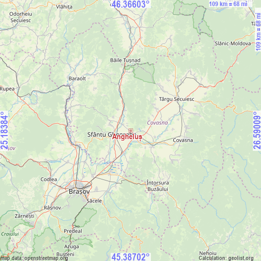
Angheluș GPS coordinates[2]
45° 52' 43.248" North, 25° 53' 13.056" East
| Map corner | latitude | longitude |
|---|---|---|
| Upper-left | 46.36603°, | 25.18384° |
| Center: | 45.87868°, | 25.88696° |
| Lower-right: | 45.38702°, | 26.59009° |
| Map W x H: | 108.9×108.9 km | = 67.7×67.7mi |
| max Lat: | 48.23793° ⇑47.8% North |
| Angheluș: | 45.87868° |
| min Lat: | ⇓52.2% South 43.65638° |
| min Long | Angheluș | max Long |
| 20.31667° | 25.88696° | 29.65403° |
| W 60.9%⇐ | ⇒39.1% E |
Elevation
Elevation of Angheluș is 570 m = 1870 ft, and this is 315.1 m = 1034 ft above average elevation for this country.
| Max E: |
1278 m = 4193 ft | 7% |
| Angheluș | 570 m 1870 ft | |
| Avg. | 254.9 m = 836 ft | |
Min E: |
-2 m = -7 ft | 93% |
See also: Romania elevation on elevation.city.
Geographical zone
Angheluș is located in North temperate zone (between Tropic of Cancer and the Arctic Circle). Distance of this North polar circle is 2299.9 km =1429.1 mi to North.| Distance of | km | miles | from Angheluș |
|---|---|---|---|
| North Pole | 4905.8 | 3048.3 | to North |
| Arctic Circle | 2299.9 | 1429.1 | to North |
| Tropic Cancer | 2495.3 | 1550.5 | to South |
| Equator | 5101.2 | 3169.7 | to South |


Nearby cities:
15 places around Angheluș: (largest is in red/bold)
• Arcuș
8.9 km =5.5 mi,  286°
286°
• Bodoc
8.4 km =5.2 mi,  340°
340°
• Boroşneu Mare
11.1 km =6.9 mi,  128°
128°
• Calnic
10.1 km =6.3 mi,  307°
307°
• Chilieni
7.9 km =4.9 mi,  234°
234°
• Dalnic
9.2 km =5.7 mi,  57°
57°
• Ghidfalău
3.7 km =2.3 mi, 309°
• Moacşa
6.3 km =3.9 mi,  102°
102°
• Olteni
10.5 km =6.5 mi, 343°
• Ozun
9.2 km =5.7 mi,  198°
198°
• Reci
4.8 km =3 mi, 131°
• Sfântu Gheorghe
8.1 km =5 mi,  260°
260°
• Sântionlunca
6.1 km =3.8 mi,  188°
188°
• Valea Crişului
10.2 km =6.3 mi, 294°
• Zălan
10.5 km =6.5 mi,  329°
329°
Sources, notices
• [Note1] Compared only with cities in Romania existing in our database
• [Src1] Map data: © OpenStreetMap contributors (CC-BY-SA)
• [Src2] Other city data from geonames.org with taken over terms of usage.
• [Src3] Geographical zone / Annual Mean Temperature by Robert A. Rohde @ Wikipedia
