Ghidfalău geodata
Ghidfalău (Covasna) is a seat of a second-order administrative division; located in Romania in Europe/Bucharest (GMT+3) time zone. With population of 2,568 people, there are 2105 cities with bigger population in this country. Compared to other cities in Romania, 52.6% of cities are located further ↓South; 60.1% of cities are located further ←West and 92.3% of cities have lower elevation than Ghidfalău. Note1


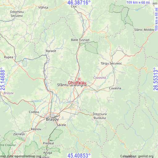
Ghidfalău GPS coordinates[2]
45° 54' 0" North, 25° 51' 0" East
| Map corner | latitude | longitude |
|---|---|---|
| Upper-left | 46.38716°, | 25.14688° |
| Center: | 45.9°, | 25.85° |
| Lower-right: | 45.40853°, | 26.55313° |
| Map W x H: | 108.8×108.8 km | = 67.6×67.6mi |
| max Lat: | 48.23793° ⇑47.4% North |
| Ghidfalău: | 45.9° |
| min Lat: | ⇓52.6% South 43.65638° |
| min Long | Ghidfalău | max Long |
| 20.31667° | 25.85° | 29.65403° |
| W 60.1%⇐ | ⇒39.9% E |
Elevation
Elevation of Ghidfalău is 555 m = 1821 ft, and this is 300.1 m = 985 ft above average elevation for this country.
| Max E: |
1278 m = 4193 ft | 7.7% |
| Ghidfalău | 555 m 1821 ft | |
| Avg. | 254.9 m = 836 ft | |
Min E: |
-2 m = -7 ft | 92.3% |
See also: Romania elevation on elevation.city.
Geographical zone
Ghidfalău is located in North temperate zone (between Tropic of Cancer and the Arctic Circle). Distance of this North polar circle is 2297.6 km =1427.7 mi to North.| Distance of | km | miles | from Ghidfalău |
|---|---|---|---|
| North Pole | 4903.5 | 3046.9 | to North |
| Arctic Circle | 2297.6 | 1427.7 | to North |
| Tropic Cancer | 2497.7 | 1552 | to South |
| Equator | 5103.6 | 3171.2 | to South |


Nearby cities:
15 places around Ghidfalău: (largest is in red/bold)
• Angheluș
3.7 km =2.3 mi,  129°
129°
• Arcuș
5.7 km =3.5 mi,  270°
270°
• Bodoc
5.6 km =3.5 mi,  0°
0°
• Calnic
6.4 km =4 mi,  305°
305°
• Chilieni
7.8 km =4.8 mi,  207°
207°
• Dalnic
10.9 km =6.8 mi,  76°
76°
• Ilieni
12.9 km =8 mi, 210°
• Moacşa
9.8 km =6.1 mi,  112°
112°
• Olteni
7.7 km =4.8 mi,  359°
359°
• Ozun
11.1 km =6.9 mi,  180°
180°
• Reci
8.5 km =5.3 mi, 130°
• Sfântu Gheorghe
6.4 km =4 mi,  234°
234°
• Sântionlunca
8.6 km =5.3 mi,  166°
166°
• Valea Crişului
6.7 km =4.2 mi,  286°
286°
• Zălan
7.1 km =4.4 mi,  339°
339°
Sources, notices
• [Note1] Compared only with cities in Romania existing in our database
• [Src1] Map data: © OpenStreetMap contributors (CC-BY-SA)
• [Src2] Other city data from geonames.org with taken over terms of usage.
• [Src3] Geographical zone / Annual Mean Temperature by Robert A. Rohde @ Wikipedia
