Ghindeni geodata
Ghindeni (Dolj) is a seat of a second-order administrative division; located in Romania in Europe/Bucharest (GMT+3) time zone. With population of 1,929 people, there are 2673 cities with bigger population in this country. Compared to other cities in Romania, 93.1% of cities are located further ↑North; 70.7% of cities are located further →East and 62.1% of cities have higher elevation than Ghindeni. Note1


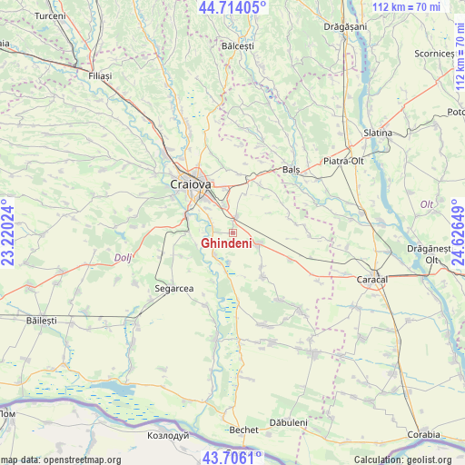
Ghindeni GPS coordinates[2]
44° 12' 44.028" North, 23° 55' 24.096" East
| Map corner | latitude | longitude |
|---|---|---|
| Upper-left | 44.71405°, | 23.22024° |
| Center: | 44.21223°, | 23.92336° |
| Lower-right: | 43.7061°, | 24.62649° |
| Map W x H: | 112.1×112.1 km | = 69.7×69.7mi |
| max Lat: | 48.23793° ⇑93.1% North |
| Ghindeni: | 44.21223° |
| min Lat: | ⇓6.9% South 43.65638° |
| min Long | Ghindeni | max Long |
| 20.31667° | 23.92336° | 29.65403° |
| W 29.3%⇐ | ⇒70.7% E |
Elevation
Elevation of Ghindeni is 158 m = 518 ft, and this is 96.9 m = 318 ft below average elevation for this country.
| Max E: |
1278 m = 4193 ft | 62.1% |
| Avg. | 254.9 m = 836 ft | |
| Ghindeni | 158 m = 518 ft | |
Min E: |
-2 m = -7 ft | 37.9% |
See also: Romania elevation on elevation.city.
Geographical zone
Ghindeni is located in North temperate zone (between Tropic of Cancer and the Arctic Circle). Distance of this Northern Tropic circle is 2310 km =1435.4 mi to South.| Distance of | km | miles | from Ghindeni |
|---|---|---|---|
| North Pole | 5091.1 | 3163.5 | to North |
| Arctic Circle | 2485.2 | 1544.2 | to North |
| Tropic Cancer | 2310 | 1435.4 | to South |
| Equator | 4915.9 | 3054.6 | to South |


Nearby cities:
15 places around Ghindeni: (largest is in red/bold)
• Bratovoești
9 km =5.6 mi,  191°
191°
• Bădoși
7.7 km =4.8 mi,  200°
200°
• Coşoveni
4.3 km =2.7 mi,  10°
10°
• Cârcea
6.6 km =4.1 mi,  343°
343°
• Făcăi
10.7 km =6.6 mi,  309°
309°
• Georocu Mare
10.4 km =6.5 mi,  167°
167°
• Golfin
11.7 km =7.3 mi,  41°
41°
• Leu
6.9 km =4.3 mi,  117°
117°
• Livezi
10.9 km =6.8 mi,  281°
281°
• Malu Mare
6.5 km =4 mi,  300°
300°
• Preajba
8.3 km =5.2 mi,  315°
315°
• Puțuri
10.7 km =6.6 mi,  139°
139°
• Secui
5.3 km =3.3 mi,  244°
244°
• Teasc
7.1 km =4.4 mi,  221°
221°
• Ţuglui
9.1 km =5.7 mi,  249°
249°
Sources, notices
• [Note1] Compared only with cities in Romania existing in our database
• [Src1] Map data: © OpenStreetMap contributors (CC-BY-SA)
• [Src2] Other city data from geonames.org with taken over terms of usage.
• [Src3] Geographical zone / Annual Mean Temperature by Robert A. Rohde @ Wikipedia
