Prunişor geodata
Prunişor (Mehedinţi) is a seat of a second-order administrative division; located in Romania in Europe/Bucharest (GMT+3) time zone. With population of 2,531 people, there are 2136 cities with bigger population in this country. Compared to other cities in Romania, 82.6% of cities are located further ↑North; 85.7% of cities are located further →East and 50.8% of cities have lower elevation than Prunişor. Note1


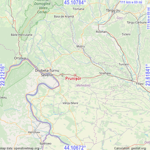
Prunişor GPS coordinates[2]
44° 36' 33.984" North, 22° 54' 55.008" East
| Map corner | latitude | longitude |
|---|---|---|
| Upper-left | 45.10784°, | 22.21216° |
| Center: | 44.60944°, | 22.91528° |
| Lower-right: | 44.10672°, | 23.61841° |
| Map W x H: | 111.3×111.3 km | = 69.2×69.2mi |
| max Lat: | 48.23793° ⇑82.6% North |
| Prunişor: | 44.60944° |
| min Lat: | ⇓17.4% South 43.65638° |
| min Long | Prunişor | max Long |
| 20.31667° | 22.91528° | 29.65403° |
| W 14.3%⇐ | ⇒85.7% E |
Elevation
Elevation of Prunişor is 216 m = 709 ft, and this is 38.9 m = 128 ft below average elevation for this country.
| Max E: |
1278 m = 4193 ft | 49.2% |
| Avg. | 254.9 m = 836 ft | |
| Prunişor | 216 m = 709 ft | |
Min E: |
-2 m = -7 ft | 50.8% |
See also: Romania elevation on elevation.city.
Geographical zone
Prunişor is located in North temperate zone (between Tropic of Cancer and the Arctic Circle). Distance of this Northern Tropic circle is 2354.2 km =1462.8 mi to South.| Distance of | km | miles | from Prunişor |
|---|---|---|---|
| North Pole | 5047 | 3136.1 | to North |
| Arctic Circle | 2441.1 | 1516.8 | to North |
| Tropic Cancer | 2354.2 | 1462.8 | to South |
| Equator | 4960.1 | 3082.1 | to South |


Nearby cities:
15 places around Prunişor: (largest is in red/bold)
• Bistrița
10.5 km =6.5 mi,  255°
255°
• Corcova
14.7 km =9.1 mi,  46°
46°
• Cordun
13.3 km =8.3 mi, 50°
• Cotoroaia
10.4 km =6.5 mi,  64°
64°
• Căzăneşti
12.8 km =8 mi,  351°
351°
• Hinova
13.4 km =8.3 mi,  235°
235°
• Husnicioara
9.6 km =6 mi,  322°
322°
• Livezile
11.6 km =7.2 mi,  200°
200°
• Lupșa de Sus
13.9 km =8.6 mi,  10°
10°
• Poroina Mare
12.8 km =8 mi,  172°
172°
• Severinești
9.7 km =6 mi, 14°
• Stignița
14.6 km =9.1 mi,  152°
152°
• Tâmna
9.3 km =5.8 mi,  120°
120°
• Valea Ursului
11.3 km =7 mi,  100°
100°
• Voloiac
14.6 km =9.1 mi,  86°
86°
Sources, notices
• [Note1] Compared only with cities in Romania existing in our database
• [Src1] Map data: © OpenStreetMap contributors (CC-BY-SA)
• [Src2] Other city data from geonames.org with taken over terms of usage.
• [Src3] Geographical zone / Annual Mean Temperature by Robert A. Rohde @ Wikipedia
