Păușa geodata
Păușa (Sălaj) is a populated place; located in Romania in Europe/Bucharest (GMT+3) time zone. With population of 533 people, there are 6748 cities with bigger population in this country. Compared to other cities in Romania, 81.1% of cities are located further ↓South; 82.3% of cities are located further →East and 63.4% of cities have lower elevation than Păușa. Note1


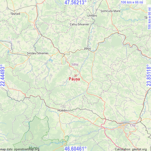
Păușa GPS coordinates[2]
47° 5' 7.872" North, 23° 8' 52.98" East
| Map corner | latitude | longitude |
|---|---|---|
| Upper-left | 47.56213°, | 22.44493° |
| Center: | 47.08552°, | 23.14805° |
| Lower-right: | 46.60461°, | 23.85118° |
| Map W x H: | 106.5×106.5 km | = 66.2×66.2mi |
| max Lat: | 48.23793° ⇑18.9% North |
| Păușa: | 47.08552° |
| min Lat: | ⇓81.1% South 43.65638° |
| min Long | Păușa | max Long |
| 20.31667° | 23.14805° | 29.65403° |
| W 17.7%⇐ | ⇒82.3% E |
Elevation
Elevation of Păușa is 281 m = 922 ft, and this is 26.1 m = 86 ft above average elevation for this country.
| Max E: |
1278 m = 4193 ft | 36.6% |
| Păușa | 281 m 922 ft | |
| Avg. | 254.9 m = 836 ft | |
Min E: |
-2 m = -7 ft | 63.4% |
See also: Romania elevation on elevation.city.
Geographical zone
Păușa is located in North temperate zone (between Tropic of Cancer and the Arctic Circle). Distance of this North polar circle is 2165.8 km =1345.8 mi to North.| Distance of | km | miles | from Păușa |
|---|---|---|---|
| North Pole | 4771.6 | 2964.9 | to North |
| Arctic Circle | 2165.8 | 1345.8 | to North |
| Tropic Cancer | 2629.5 | 1633.9 | to South |
| Equator | 5235.4 | 3253.1 | to South |


Nearby cities:
15 places around Păușa: (largest is in red/bold)
• Aghireș
13 km =8.1 mi,  310°
310°
• Agrij
4.2 km =2.6 mi,  240°
240°
• Brebi
14.1 km =8.8 mi,  15°
15°
• Buciumi
8.5 km =5.3 mi,  226°
226°
• Chendrea
12.1 km =7.5 mi,  70°
70°
• Cuzăplac
13.8 km =8.6 mi,  163°
163°
• Hida
10.5 km =6.5 mi,  101°
101°
• Jac
9.8 km =6.1 mi, 22°
• Meseşenii de Jos
14.4 km =8.9 mi,  299°
299°
• Meseșenii de Sus
13.2 km =8.2 mi,  290°
290°
• Moigrad-Porolissum
12.4 km =7.7 mi,  358°
358°
• Românaşi
3.1 km =1.9 mi,  58°
58°
• Sânmihaiu Almaşului
13.8 km =8.6 mi,  123°
123°
• Treznea
2.9 km =1.8 mi, 304°
• Zimbor
13.1 km =8.1 mi,  136°
136°
Sources, notices
• [Note1] Compared only with cities in Romania existing in our database
• [Src1] Map data: © OpenStreetMap contributors (CC-BY-SA)
• [Src2] Other city data from geonames.org with taken over terms of usage.
• [Src3] Geographical zone / Annual Mean Temperature by Robert A. Rohde @ Wikipedia
