Pădureni geodata
Pădureni (Giurgiu) is a populated place; located in Romania in Europe/Bucharest (GMT+3) time zone. With population of 1,597 people, there are 3053 cities with bigger population in this country. Compared to other cities in Romania, 89.8% of cities are located further ↑North; 59.3% of cities are located further ←West and 83.5% of cities have higher elevation than Pădureni. Note1


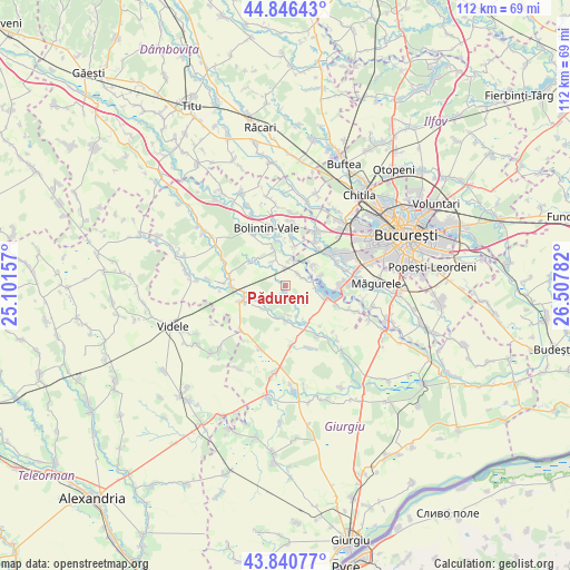
Pădureni GPS coordinates[2]
44° 20' 44.736" North, 25° 48' 16.884" East
| Map corner | latitude | longitude |
|---|---|---|
| Upper-left | 44.84643°, | 25.10157° |
| Center: | 44.34576°, | 25.80469° |
| Lower-right: | 43.84077°, | 26.50782° |
| Map W x H: | 111.8×111.8 km | = 69.5×69.5mi |
| max Lat: | 48.23793° ⇑89.8% North |
| Pădureni: | 44.34576° |
| min Lat: | ⇓10.2% South 43.65638° |
| min Long | Pădureni | max Long |
| 20.31667° | 25.80469° | 29.65403° |
| W 59.3%⇐ | ⇒40.7% E |
Elevation
Elevation of Pădureni is 83 m = 272 ft, and this is 171.9 m = 564 ft below average elevation for this country.
| Max E: |
1278 m = 4193 ft | 83.5% |
| Avg. | 254.9 m = 836 ft | |
| Pădureni | 83 m = 272 ft | |
Min E: |
-2 m = -7 ft | 16.5% |
See also: Romania elevation on elevation.city.
Geographical zone
Pădureni is located in North temperate zone (between Tropic of Cancer and the Arctic Circle). Distance of this Northern Tropic circle is 2324.9 km =1444.6 mi to South.| Distance of | km | miles | from Pădureni |
|---|---|---|---|
| North Pole | 5076.3 | 3154.3 | to North |
| Arctic Circle | 2470.4 | 1535 | to North |
| Tropic Cancer | 2324.9 | 1444.6 | to South |
| Equator | 4930.8 | 3063.9 | to South |


Nearby cities:
15 places around Pădureni: (largest is in red/bold)
• Bulbucata
6.9 km =4.3 mi,  180°
180°
• Buturugeni
3.3 km =2.1 mi,  48°
48°
• Clejani
8.9 km =5.5 mi,  250°
250°
• Crivina
9.6 km =6 mi,  351°
351°
• Gorneni
8.6 km =5.3 mi,  146°
146°
• Grădinari
5.2 km =3.2 mi,  9°
9°
• Hobaia
5.4 km =3.4 mi,  335°
335°
• Mihăileşti
8.5 km =5.3 mi,  104°
104°
• Neajlovu
5.3 km =3.3 mi,  228°
228°
• Ogrezeni
8.7 km =5.4 mi, 340°
• Podișor
8.7 km =5.4 mi,  304°
304°
• Podu Doamnei
6.3 km =3.9 mi, 228°
• Tântava
7.9 km =4.9 mi, 11°
• Zorile
3.7 km =2.3 mi,  2°
2°
• Țegheș
6.8 km =4.2 mi, 53°
Sources, notices
• [Note1] Compared only with cities in Romania existing in our database
• [Src1] Map data: © OpenStreetMap contributors (CC-BY-SA)
• [Src2] Other city data from geonames.org with taken over terms of usage.
• [Src3] Geographical zone / Annual Mean Temperature by Robert A. Rohde @ Wikipedia
