Ghilad geodata
Ghilad (Timiş) is a seat of a second-order administrative division; located in Romania in Europe/Bucharest (GMT+3) time zone. With population of 1,842 people, there are 2770 cities with bigger population in this country. Compared to other cities in Romania, 56% of cities are located further ↑North; 98.9% of cities are located further →East and 84.4% of cities have higher elevation than Ghilad. Note1


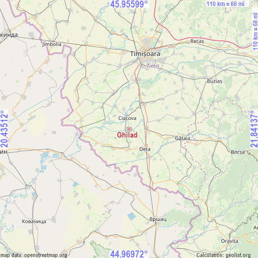
Ghilad GPS coordinates[2]
45° 27' 54.036" North, 21° 8' 17.664" East
| Map corner | latitude | longitude |
|---|---|---|
| Upper-left | 45.95599°, | 20.43512° |
| Center: | 45.46501°, | 21.13824° |
| Lower-right: | 44.96972°, | 21.84137° |
| Map W x H: | 109.7×109.7 km | = 68.2×68.2mi |
| max Lat: | 48.23793° ⇑56% North |
| Ghilad: | 45.46501° |
| min Lat: | ⇓44% South 43.65638° |
| min Long | Ghilad | max Long |
| 20.31667° | 21.13824° | 29.65403° |
| W 1.1%⇐ | ⇒98.9% E |
Elevation
Elevation of Ghilad is 80 m = 262 ft, and this is 174.9 m = 574 ft below average elevation for this country.
| Max E: |
1278 m = 4193 ft | 84.4% |
| Avg. | 254.9 m = 836 ft | |
| Ghilad | 80 m = 262 ft | |
Min E: |
-2 m = -7 ft | 15.6% |
See also: Romania elevation on elevation.city.
Geographical zone
Ghilad is located in North temperate zone (between Tropic of Cancer and the Arctic Circle). Distance of this North polar circle is 2345.9 km =1457.7 mi to North.| Distance of | km | miles | from Ghilad |
|---|---|---|---|
| North Pole | 4951.8 | 3076.9 | to North |
| Arctic Circle | 2345.9 | 1457.7 | to North |
| Tropic Cancer | 2449.3 | 1521.9 | to South |
| Equator | 5055.2 | 3141.2 | to South |


Nearby cities:
15 places around Ghilad: (largest is in red/bold)
• Banloc
8.6 km =5.3 mi,  181°
181°
• Cebza
11.2 km =7 mi,  330°
330°
• Ciacova
4.8 km =3 mi,  351°
351°
• Crai Nou
11.1 km =6.9 mi,  283°
283°
• Deta
10.8 km =6.7 mi,  141°
141°
• Dolaț
6.9 km =4.3 mi,  235°
235°
• Giera
13.1 km =8.1 mi, 240°
• Jebel
11.7 km =7.3 mi,  30°
30°
• Livezile
10.4 km =6.5 mi,  217°
217°
• Obad
8.5 km =5.3 mi,  9°
9°
• Opatița
11.7 km =7.3 mi,  118°
118°
• Petroman
8.7 km =5.4 mi, 347°
• Rudna
10.8 km =6.7 mi,  290°
290°
• Soca
10.6 km =6.6 mi,  168°
168°
• Voiteg
7.9 km =4.9 mi,  86°
86°
Sources, notices
• [Note1] Compared only with cities in Romania existing in our database
• [Src1] Map data: © OpenStreetMap contributors (CC-BY-SA)
• [Src2] Other city data from geonames.org with taken over terms of usage.
• [Src3] Geographical zone / Annual Mean Temperature by Robert A. Rohde @ Wikipedia
