Banloc geodata
Banloc (Timiş) is a seat of a second-order administrative division; located in Romania in Europe/Bucharest (GMT+3) time zone. With population of 4,497 people, there are 953 cities with bigger population in this country. Compared to other cities in Romania, 57.2% of cities are located further ↑North; 98.9% of cities are located further →East and 83.5% of cities have higher elevation than Banloc. Note1


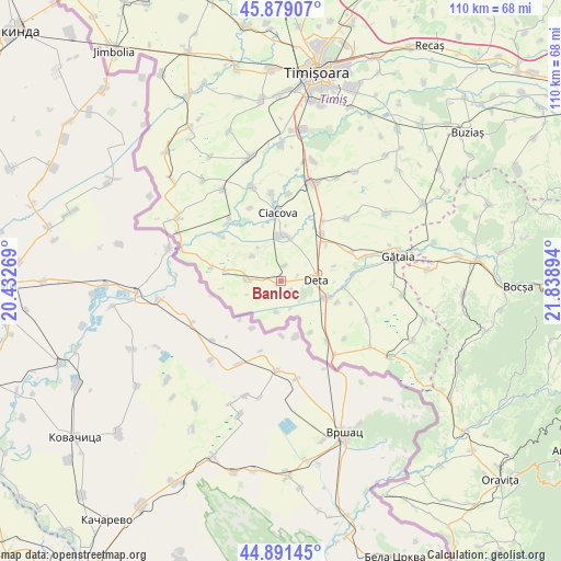
Banloc GPS coordinates[2]
45° 23' 14.712" North, 21° 8' 8.916" East
| Map corner | latitude | longitude |
|---|---|---|
| Upper-left | 45.87907°, | 20.43269° |
| Center: | 45.38742°, | 21.13581° |
| Lower-right: | 44.89145°, | 21.83894° |
| Map W x H: | 109.8×109.8 km | = 68.2×68.2mi |
| max Lat: | 48.23793° ⇑57.2% North |
| Banloc: | 45.38742° |
| min Lat: | ⇓42.8% South 43.65638° |
| min Long | Banloc | max Long |
| 20.31667° | 21.13581° | 29.65403° |
| W 1.1%⇐ | ⇒98.9% E |
Elevation
Elevation of Banloc is 83 m = 272 ft, and this is 171.9 m = 564 ft below average elevation for this country.
| Max E: |
1278 m = 4193 ft | 83.5% |
| Avg. | 254.9 m = 836 ft | |
| Banloc | 83 m = 272 ft | |
Min E: |
-2 m = -7 ft | 16.5% |
See also: Romania elevation on elevation.city.
Geographical zone
Banloc is located in North temperate zone (between Tropic of Cancer and the Arctic Circle). Distance of this North polar circle is 2354.6 km =1463.1 mi to North.| Distance of | km | miles | from Banloc |
|---|---|---|---|
| North Pole | 4960.5 | 3082.3 | to North |
| Arctic Circle | 2354.6 | 1463.1 | to North |
| Tropic Cancer | 2440.7 | 1516.6 | to South |
| Equator | 5046.6 | 3135.8 | to South |


Nearby cities:
15 places around Banloc: (largest is in red/bold)
• Breștea
11.6 km =7.2 mi,  109°
109°
• Ciacova
13.4 km =8.3 mi,  357°
357°
• Crai Nou
15.4 km =9.6 mi,  316°
316°
• Denta
9.6 km =6 mi, 112°
• Deta
6.9 km =4.3 mi,  88°
88°
• Dolaț
7.2 km =4.5 mi,  310°
310°
• Ghilad
8.6 km =5.3 mi,  1°
1°
• Giera
11.4 km =7.1 mi,  281°
281°
• Livezile
6.1 km =3.8 mi,  272°
272°
• Opatița
10.9 km =6.8 mi,  74°
74°
• Rudna
15.8 km =9.8 mi, 321°
• Soca
2.9 km =1.8 mi,  129°
129°
• Stamora Germană
14.8 km =9.2 mi,  142°
142°
• Sângeorge
14.4 km =8.9 mi,  84°
84°
• Voiteg
12.1 km =7.5 mi,  41°
41°
Sources, notices
• [Note1] Compared only with cities in Romania existing in our database
• [Src1] Map data: © OpenStreetMap contributors (CC-BY-SA)
• [Src2] Other city data from geonames.org with taken over terms of usage.
• [Src3] Geographical zone / Annual Mean Temperature by Robert A. Rohde @ Wikipedia
