Olteni geodata
Olteni (Covasna) is a populated place; located in Romania in Europe/Bucharest (GMT+3) time zone. With population of 608 people, there are 6143 cities with bigger population in this country. Compared to other cities in Romania, 54.5% of cities are located further ↓South; 60.1% of cities are located further ←West and 92% of cities have lower elevation than Olteni. Note1


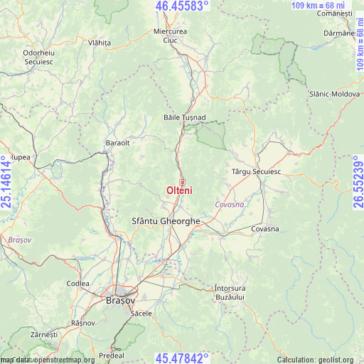
Olteni GPS coordinates[2]
45° 58' 9.408" North, 25° 50' 57.336" East
| Map corner | latitude | longitude |
|---|---|---|
| Upper-left | 46.45583°, | 25.14614° |
| Center: | 45.96928°, | 25.84926° |
| Lower-right: | 45.47842°, | 26.55239° |
| Map W x H: | 108.7×108.7 km | = 67.5×67.5mi |
| max Lat: | 48.23793° ⇑45.5% North |
| Olteni: | 45.96928° |
| min Lat: | ⇓54.5% South 43.65638° |
| min Long | Olteni | max Long |
| 20.31667° | 25.84926° | 29.65403° |
| W 60.1%⇐ | ⇒39.9% E |
Elevation
Elevation of Olteni is 547 m = 1795 ft, and this is 292.1 m = 958 ft above average elevation for this country.
| Max E: |
1278 m = 4193 ft | 8% |
| Olteni | 547 m 1795 ft | |
| Avg. | 254.9 m = 836 ft | |
Min E: |
-2 m = -7 ft | 92% |
See also: Romania elevation on elevation.city.
Geographical zone
Olteni is located in North temperate zone (between Tropic of Cancer and the Arctic Circle). Distance of this North polar circle is 2289.9 km =1422.9 mi to North.| Distance of | km | miles | from Olteni |
|---|---|---|---|
| North Pole | 4895.8 | 3042.1 | to North |
| Arctic Circle | 2289.9 | 1422.9 | to North |
| Tropic Cancer | 2505.4 | 1556.8 | to South |
| Equator | 5111.3 | 3176 | to South |


Nearby cities:
15 places around Olteni: (largest is in red/bold)
• Aita Seacă
14.2 km =8.8 mi,  302°
302°
• Angheluș
10.5 km =6.5 mi,  163°
163°
• Arcuș
9.5 km =5.9 mi,  216°
216°
• Bixad
14.6 km =9.1 mi,  5°
5°
• Bodoc
2.1 km =1.3 mi,  178°
178°
• Calnic
6.5 km =4 mi,  231°
231°
• Cernat
14.4 km =8.9 mi,  98°
98°
• Dalnic
11.9 km =7.4 mi,  116°
116°
• Ghidfalău
7.7 km =4.8 mi, 179°
• Malnaş
5.4 km =3.4 mi,  346°
346°
• Micfalău
9.4 km =5.8 mi, 354°
• Moacşa
14.6 km =9.1 mi,  141°
141°
• Sfântu Gheorghe
12.5 km =7.8 mi,  204°
204°
• Valea Crişului
8.7 km =5.4 mi, 227°
• Zălan
2.7 km =1.7 mi,  247°
247°
Sources, notices
• [Note1] Compared only with cities in Romania existing in our database
• [Src1] Map data: © OpenStreetMap contributors (CC-BY-SA)
• [Src2] Other city data from geonames.org with taken over terms of usage.
• [Src3] Geographical zone / Annual Mean Temperature by Robert A. Rohde @ Wikipedia
