Ruginoasa geodata
Ruginoasa (Iaşi) is a seat of a second-order administrative division; located in Romania in Europe/Bucharest (GMT+3) time zone. With population of 6,220 people, there are 508 cities with bigger population in this country. Compared to other cities in Romania, 85.3% of cities are located further ↓South; 79.7% of cities are located further ←West and 65.5% of cities have lower elevation than Ruginoasa. Note1


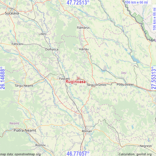
Ruginoasa GPS coordinates[2]
47° 15' 0" North, 26° 51' 0" East
| Map corner | latitude | longitude |
|---|---|---|
| Upper-left | 47.72513°, | 26.14688° |
| Center: | 47.25°, | 26.85° |
| Lower-right: | 46.77057°, | 27.55313° |
| Map W x H: | 106.1×106.1 km | = 65.9×65.9mi |
| max Lat: | 48.23793° ⇑14.7% North |
| Ruginoasa: | 47.25° |
| min Lat: | ⇓85.3% South 43.65638° |
| min Long | Ruginoasa | max Long |
| 20.31667° | 26.85° | 29.65403° |
| W 79.7%⇐ | ⇒20.3% E |
Elevation
Elevation of Ruginoasa is 293 m = 961 ft, and this is 38.1 m = 125 ft above average elevation for this country.
| Max E: |
1278 m = 4193 ft | 34.5% |
| Ruginoasa | 293 m 961 ft | |
| Avg. | 254.9 m = 836 ft | |
Min E: |
-2 m = -7 ft | 65.5% |
See also: Romania elevation on elevation.city.
Geographical zone
Ruginoasa is located in North temperate zone (between Tropic of Cancer and the Arctic Circle). Distance of this North polar circle is 2147.5 km =1334.4 mi to North.| Distance of | km | miles | from Ruginoasa |
|---|---|---|---|
| North Pole | 4753.4 | 2953.6 | to North |
| Arctic Circle | 2147.5 | 1334.4 | to North |
| Tropic Cancer | 2647.8 | 1645.3 | to South |
| Equator | 5253.7 | 3264.5 | to South |


Nearby cities:
15 places around Ruginoasa: (largest is in red/bold)
• Costești
6 km =3.7 mi,  106°
106°
• Cucuteni
7.3 km =4.5 mi,  59°
59°
• Dumbrăvița
0.8 km =0.5 mi,  310°
310°
• Giurgești
4.4 km =2.7 mi,  89°
89°
• Gura Bâdiliței
9.3 km =5.8 mi, 306°
• Heleșteni
5.6 km =3.5 mi,  158°
158°
• Hărmăneasa
5.7 km =3.5 mi,  167°
167°
• Hărmăneștii Noi
3.9 km =2.4 mi,  275°
275°
• Hărmăneștii Vechi
4.1 km =2.5 mi,  318°
318°
• Lunca
9.2 km =5.7 mi,  292°
292°
• Oboroceni
8.4 km =5.2 mi, 165°
• Paşcani
9.6 km =6 mi,  267°
267°
• Rediu
1.5 km =0.9 mi,  135°
135°
• Stolniceni-Prăjescu
9.6 km =6 mi,  233°
233°
• Todireşti
7.5 km =4.7 mi,  350°
350°
Sources, notices
• [Note1] Compared only with cities in Romania existing in our database
• [Src1] Map data: © OpenStreetMap contributors (CC-BY-SA)
• [Src2] Other city data from geonames.org with taken over terms of usage.
• [Src3] Geographical zone / Annual Mean Temperature by Robert A. Rohde @ Wikipedia
