Giurgești geodata
Giurgești (Iaşi) is a populated place; located in Romania in Europe/Bucharest (GMT+3) time zone. With population of 535 people, there are 6723 cities with bigger population in this country. Compared to other cities in Romania, 85.4% of cities are located further ↓South; 81.2% of cities are located further ←West and 50.5% of cities have higher elevation than Giurgești. Note1


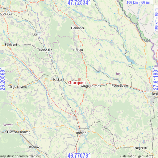
Giurgești GPS coordinates[2]
47° 15' 0.756" North, 26° 54' 31.68" East
| Map corner | latitude | longitude |
|---|---|---|
| Upper-left | 47.72534°, | 26.20568° |
| Center: | 47.25021°, | 26.9088° |
| Lower-right: | 46.77078°, | 27.61193° |
| Map W x H: | 106.1×106.1 km | = 65.9×65.9mi |
| max Lat: | 48.23793° ⇑14.6% North |
| Giurgești: | 47.25021° |
| min Lat: | ⇓85.4% South 43.65638° |
| min Long | Giurgești | max Long |
| 20.31667° | 26.9088° | 29.65403° |
| W 81.2%⇐ | ⇒18.8% E |
Elevation
Elevation of Giurgești is 209 m = 686 ft, and this is 45.9 m = 151 ft below average elevation for this country.
| Max E: |
1278 m = 4193 ft | 50.5% |
| Avg. | 254.9 m = 836 ft | |
| Giurgești | 209 m = 686 ft | |
Min E: |
-2 m = -7 ft | 49.5% |
See also: Romania elevation on elevation.city.
Geographical zone
Giurgești is located in North temperate zone (between Tropic of Cancer and the Arctic Circle). Distance of this North polar circle is 2147.4 km =1334.3 mi to North.| Distance of | km | miles | from Giurgești |
|---|---|---|---|
| North Pole | 4753.3 | 2953.6 | to North |
| Arctic Circle | 2147.4 | 1334.3 | to North |
| Tropic Cancer | 2647.8 | 1645.3 | to South |
| Equator | 5253.7 | 3264.5 | to South |


Nearby cities:
15 places around Giurgești: (largest is in red/bold)
• Balș
7.3 km =4.5 mi,  45°
45°
• Boureni
5.4 km =3.4 mi,  72°
72°
• Costești
2.2 km =1.4 mi,  143°
143°
• Cucuteni
4.1 km =2.5 mi,  26°
26°
• Cârjoaia
10 km =6.2 mi,  359°
359°
• Dumbrăvița
5.1 km =3.2 mi,  275°
275°
• Heleșteni
5.8 km =3.6 mi,  204°
204°
• Hărmăneasa
6.4 km =4 mi,  209°
209°
• Hărmăneștii Noi
8.3 km =5.2 mi,  272°
272°
• Hărmăneștii Vechi
7.8 km =4.8 mi,  292°
292°
• Oboroceni
8.5 km =5.3 mi, 196°
• Rediu
3.6 km =2.2 mi,  251°
251°
• Ruginoasa
4.4 km =2.7 mi, 269°
• Todireşti
9.3 km =5.8 mi,  322°
322°
• Târgu Frumos
8.9 km =5.5 mi,  129°
129°
Sources, notices
• [Note1] Compared only with cities in Romania existing in our database
• [Src1] Map data: © OpenStreetMap contributors (CC-BY-SA)
• [Src2] Other city data from geonames.org with taken over terms of usage.
• [Src3] Geographical zone / Annual Mean Temperature by Robert A. Rohde @ Wikipedia
