Hilișeu-Crișan geodata
Hilișeu-Crișan (Botoşani) is a populated place; located in Romania in Europe/Bucharest (GMT+3) time zone. With population of 961 people, there are 4418 cities with bigger population in this country. Compared to other cities in Romania, 99.4% of cities are located further ↓South; 67.6% of cities are located further ←West and 53.3% of cities have higher elevation than Hilișeu-Crișan. Note1


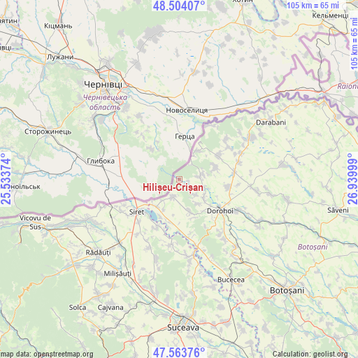
Hilișeu-Crișan GPS coordinates[2]
48° 2' 9.816" North, 26° 14' 12.696" East
| Map corner | latitude | longitude |
|---|---|---|
| Upper-left | 48.50407°, | 25.53374° |
| Center: | 48.03606°, | 26.23686° |
| Lower-right: | 47.56376°, | 26.93999° |
| Map W x H: | 104.6×104.6 km | = 65×65mi |
| max Lat: | 48.23793° ⇑0.6% North |
| Hilișeu-Crișan: | 48.03606° |
| min Lat: | ⇓99.4% South 43.65638° |
| min Long | Hilișeu-Crișa | max Long |
| 20.31667° | 26.23686° | 29.65403° |
| W 67.6%⇐ | ⇒32.4% E |
Elevation
Elevation of Hilișeu-Crișan is 195 m = 640 ft, and this is 59.9 m = 197 ft below average elevation for this country.
| Max E: |
1278 m = 4193 ft | 53.3% |
| Avg. | 254.9 m = 836 ft | |
| Hilișeu-Crișan | 195 m = 640 ft | |
Min E: |
-2 m = -7 ft | 46.7% |
See also: Romania elevation on elevation.city.
Geographical zone
Hilișeu-Crișan is located in North temperate zone (between Tropic of Cancer and the Arctic Circle). Distance of this North polar circle is 2060.1 km =1280.1 mi to North.| Distance of | km | miles | from Hilișeu-Crișan |
|---|---|---|---|
| North Pole | 4666 | 2899.3 | to North |
| Arctic Circle | 2060.1 | 1280.1 | to North |
| Tropic Cancer | 2735.2 | 1699.6 | to South |
| Equator | 5341.1 | 3318.8 | to South |


Nearby cities:
15 places around Hilișeu-Crișan: (largest is in red/bold)
• Corjăuți
2.8 km =1.7 mi,  95°
95°
• Cândeşti
11.7 km =7.3 mi,  193°
193°
• Dersca
6.5 km =4 mi,  205°
205°
• Fundu Herții
10.3 km =6.4 mi,  33°
33°
• Hilişeu-Horia
1 km =0.6 mi,  107°
107°
• Hilișeu-Cloșca
7.6 km =4.7 mi, 107°
• Ibăneşti
10.2 km =6.3 mi,  70°
70°
• Iezer
9.3 km =5.8 mi,  129°
129°
• Lozna
9.9 km =6.2 mi,  162°
162°
• Mihăileni
10.1 km =6.3 mi,  219°
219°
• Pomârla
6.8 km =4.2 mi,  60°
60°
• Pârâu Negru
9.3 km =5.8 mi, 209°
• Pădureni
9.1 km =5.7 mi,  139°
139°
• Străteni
11.9 km =7.4 mi, 158°
• Şendriceni
11.6 km =7.2 mi, 144°
Sources, notices
• [Note1] Compared only with cities in Romania existing in our database
• [Src1] Map data: © OpenStreetMap contributors (CC-BY-SA)
• [Src2] Other city data from geonames.org with taken over terms of usage.
• [Src3] Geographical zone / Annual Mean Temperature by Robert A. Rohde @ Wikipedia
