Hilişeu-Horia geodata
Hilişeu-Horia (Botoşani) is a seat of a second-order administrative division; located in Romania in Europe/Bucharest (GMT+3) time zone. With population of 3,684 people, there are 1337 cities with bigger population in this country. Compared to other cities in Romania, 99.3% of cities are located further ↓South; 67.8% of cities are located further ←West and 52.1% of cities have higher elevation than Hilişeu-Horia. Note1


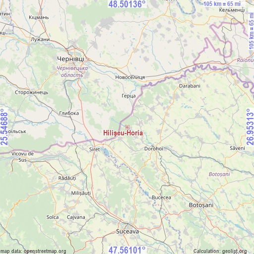
Hilişeu-Horia GPS coordinates[2]
48° 1' 59.988" North, 26° 15' 0" East
| Map corner | latitude | longitude |
|---|---|---|
| Upper-left | 48.50136°, | 25.54688° |
| Center: | 48.03333°, | 26.25° |
| Lower-right: | 47.56101°, | 26.95313° |
| Map W x H: | 104.6×104.6 km | = 65×65mi |
| max Lat: | 48.23793° ⇑0.7% North |
| Hilişeu-Horia: | 48.03333° |
| min Lat: | ⇓99.3% South 43.65638° |
| min Long | Hilişeu-Horia | max Long |
| 20.31667° | 26.25° | 29.65403° |
| W 67.8%⇐ | ⇒32.2% E |
Elevation
Elevation of Hilişeu-Horia is 201 m = 659 ft, and this is 53.9 m = 177 ft below average elevation for this country.
| Max E: |
1278 m = 4193 ft | 52.1% |
| Avg. | 254.9 m = 836 ft | |
| Hilişeu-Horia | 201 m = 659 ft | |
Min E: |
-2 m = -7 ft | 47.9% |
See also: Romania elevation on elevation.city.
Geographical zone
Hilişeu-Horia is located in North temperate zone (between Tropic of Cancer and the Arctic Circle). Distance of this North polar circle is 2060.4 km =1280.3 mi to North.| Distance of | km | miles | from Hilişeu-Horia |
|---|---|---|---|
| North Pole | 4666.3 | 2899.5 | to North |
| Arctic Circle | 2060.4 | 1280.3 | to North |
| Tropic Cancer | 2734.9 | 1699.4 | to South |
| Equator | 5340.8 | 3318.6 | to South |


Nearby cities:
15 places around Hilişeu-Horia: (largest is in red/bold)
• Corjăuți
1.8 km =1.1 mi,  88°
88°
• Cândeşti
11.7 km =7.3 mi,  198°
198°
• Dersca
6.7 km =4.2 mi,  213°
213°
• Fundu Herții
10.1 km =6.3 mi,  28°
28°
• Hilișeu-Cloșca
6.6 km =4.1 mi,  107°
107°
• Hilișeu-Crișan
1 km =0.6 mi,  287°
287°
• Ibăneşti
9.4 km =5.8 mi,  66°
66°
• Iezer
8.3 km =5.2 mi,  131°
131°
• Lozna
9.3 km =5.8 mi,  167°
167°
• Mihăileni
10.5 km =6.5 mi,  225°
225°
• Pomârla
6.2 km =3.9 mi,  53°
53°
• Pârâu Negru
9.6 km =6 mi,  215°
215°
• Pădureni
8.2 km =5.1 mi,  142°
142°
• Străteni
11.3 km =7 mi,  162°
162°
• Şendriceni
10.8 km =6.7 mi,  147°
147°
Sources, notices
• [Note1] Compared only with cities in Romania existing in our database
• [Src1] Map data: © OpenStreetMap contributors (CC-BY-SA)
• [Src2] Other city data from geonames.org with taken over terms of usage.
• [Src3] Geographical zone / Annual Mean Temperature by Robert A. Rohde @ Wikipedia
