Vâlcele geodata
Vâlcele (Olt) is a populated place; located in Romania in Europe/Bucharest (GMT+3) time zone. With population of 1,097 people, there are 3998 cities with bigger population in this country. Compared to other cities in Romania, 91.3% of cities are located further ↑North; 59.7% of cities are located further →East and 70.9% of cities have higher elevation than Vâlcele. Note1


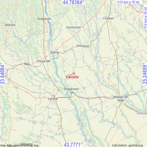
Vâlcele GPS coordinates[2]
44° 16' 57.468" North, 24° 32' 37.536" East
| Map corner | latitude | longitude |
|---|---|---|
| Upper-left | 44.78384°, | 23.84064° |
| Center: | 44.28263°, | 24.54376° |
| Lower-right: | 43.7771°, | 25.24689° |
| Map W x H: | 111.9×111.9 km | = 69.5×69.5mi |
| max Lat: | 48.23793° ⇑91.3% North |
| Vâlcele: | 44.28263° |
| min Lat: | ⇓8.7% South 43.65638° |
| min Long | Vâlcele | max Long |
| 20.31667° | 24.54376° | 29.65403° |
| W 40.3%⇐ | ⇒59.7% E |
Elevation
Elevation of Vâlcele is 124 m = 407 ft, and this is 130.9 m = 429 ft below average elevation for this country.
| Max E: |
1278 m = 4193 ft | 70.9% |
| Avg. | 254.9 m = 836 ft | |
| Vâlcele | 124 m = 407 ft | |
Min E: |
-2 m = -7 ft | 29.1% |
See also: Romania elevation on elevation.city.
Geographical zone
Vâlcele is located in North temperate zone (between Tropic of Cancer and the Arctic Circle). Distance of this Northern Tropic circle is 2317.8 km =1440.2 mi to South.| Distance of | km | miles | from Vâlcele |
|---|---|---|---|
| North Pole | 5083.3 | 3158.6 | to North |
| Arctic Circle | 2477.4 | 1539.4 | to North |
| Tropic Cancer | 2317.8 | 1440.2 | to South |
| Equator | 4923.8 | 3059.5 | to South |


Nearby cities:
15 places around Vâlcele: (largest is in red/bold)
• Alimănești
2.9 km =1.8 mi,  187°
187°
• Brebeni
12 km =7.5 mi,  321°
321°
• Bălănești
6.1 km =3.8 mi,  233°
233°
• Bărcănești
2 km =1.2 mi,  7°
7°
• Catanele
11.1 km =6.9 mi, 7°
• Comani
11.8 km =7.3 mi,  200°
200°
• Coteana
6.4 km =4 mi,  287°
287°
• Greci
5.4 km =3.4 mi, 13°
• Ipotești
12.3 km =7.6 mi, 292°
• Izvoarele
2.8 km =1.7 mi, 230°
• Lisa
7.8 km =4.8 mi,  353°
353°
• Măgura
12.4 km =7.7 mi,  4°
4°
• Mărunţei
11.1 km =6.9 mi,  213°
213°
• Schitu
7.7 km =4.8 mi, 13°
• Vâlcelele de Sus
1.2 km =0.7 mi,  79°
79°
Sources, notices
• [Note1] Compared only with cities in Romania existing in our database
• [Src1] Map data: © OpenStreetMap contributors (CC-BY-SA)
• [Src2] Other city data from geonames.org with taken over terms of usage.
• [Src3] Geographical zone / Annual Mean Temperature by Robert A. Rohde @ Wikipedia
