Călan geodata
Călan (Hunedoara) is a seat of a second-order administrative division; located in Romania in Europe/Bucharest (GMT+3) time zone. With population of 12,782 people, there are 152 cities with bigger population in this country. Compared to other cities in Romania, 51.3% of cities are located further ↑North; 84.6% of cities are located further →East and 56.4% of cities have lower elevation than Călan. Note1


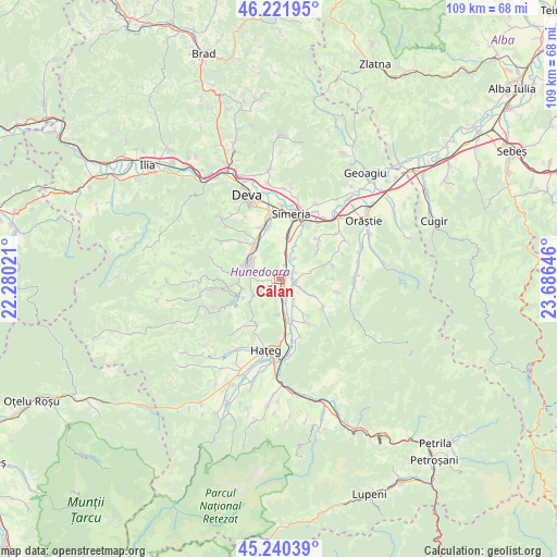
Călan GPS coordinates[2]
45° 43' 59.988" North, 22° 58' 59.988" East
| Map corner | latitude | longitude |
|---|---|---|
| Upper-left | 46.22195°, | 22.28021° |
| Center: | 45.73333°, | 22.98333° |
| Lower-right: | 45.24039°, | 23.68646° |
| Map W x H: | 109.1×109.1 km | = 67.8×67.8mi |
| max Lat: | 48.23793° ⇑51.3% North |
| Călan: | 45.73333° |
| min Lat: | ⇓48.7% South 43.65638° |
| min Long | Călan | max Long |
| 20.31667° | 22.98333° | 29.65403° |
| W 15.4%⇐ | ⇒84.6% E |
Elevation
Elevation of Călan is 245 m = 804 ft, and this is 9.9 m = 32 ft below average elevation for this country.
| Max E: |
1278 m = 4193 ft | 43.6% |
| Avg. | 254.9 m = 836 ft | |
| Călan | 245 m = 804 ft | |
Min E: |
-2 m = -7 ft | 56.4% |
See also: Romania elevation on elevation.city.
Geographical zone
Călan is located in North temperate zone (between Tropic of Cancer and the Arctic Circle). Distance of this North polar circle is 2316.1 km =1439.2 mi to North.| Distance of | km | miles | from Călan |
|---|---|---|---|
| North Pole | 4922 | 3058.4 | to North |
| Arctic Circle | 2316.1 | 1439.2 | to North |
| Tropic Cancer | 2479.2 | 1540.5 | to South |
| Equator | 5085.1 | 3159.7 | to South |


Nearby cities:
15 places around Călan: (largest is in red/bold)
• Batiz
5.2 km =3.2 mi,  16°
16°
• Boşorod
9.5 km =5.9 mi,  125°
125°
• Bretea Română
8.5 km =5.3 mi,  161°
161°
• Băcia
7.9 km =4.9 mi, 19°
• Chitid
7.2 km =4.5 mi,  115°
115°
• Cinciș-Cerna
7.9 km =4.9 mi,  243°
243°
• Cristur
11.1 km =6.9 mi,  343°
343°
• Hunedoara
6.7 km =4.2 mi,  285°
285°
• Petreni
7.4 km =4.6 mi,  27°
27°
• Peştişu Mic
10.7 km =6.6 mi,  313°
313°
• Peștișu Mare
8.8 km =5.5 mi,  330°
330°
• Răcăștia
9.3 km =5.8 mi, 294°
• Streisângeorgiu
3.1 km =1.9 mi,  102°
102°
• Teliucu Inferior
8 km =5 mi,  256°
256°
• Tâmpa
10.6 km =6.6 mi,  13°
13°
Sources, notices
• [Note1] Compared only with cities in Romania existing in our database
• [Src1] Map data: © OpenStreetMap contributors (CC-BY-SA)
• [Src2] Other city data from geonames.org with taken over terms of usage.
• [Src3] Geographical zone / Annual Mean Temperature by Robert A. Rohde @ Wikipedia
