Cinciș-Cerna geodata
Cinciș-Cerna (Hunedoara) is a populated place; located in Romania in Europe/Bucharest (GMT+3) time zone. With population of 783 people, there are 5130 cities with bigger population in this country. Compared to other cities in Romania, 51.9% of cities are located further ↑North; 86% of cities are located further →East and 74.1% of cities have lower elevation than Cinciș-Cerna. Note1


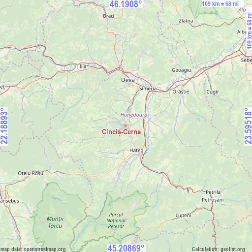
Cinciș-Cerna GPS coordinates[2]
45° 42' 6.84" North, 22° 53' 31.38" East
| Map corner | latitude | longitude |
|---|---|---|
| Upper-left | 46.1908°, | 22.18893° |
| Center: | 45.7019°, | 22.89205° |
| Lower-right: | 45.20869°, | 23.59518° |
| Map W x H: | 109.2×109.2 km | = 67.9×67.9mi |
| max Lat: | 48.23793° ⇑51.9% North |
| Cinciș-Cerna: | 45.7019° |
| min Lat: | ⇓48.1% South 43.65638° |
| min Long | Cinciș-Cerna | max Long |
| 20.31667° | 22.89205° | 29.65403° |
| W 14%⇐ | ⇒86% E |
Elevation
Elevation of Cinciș-Cerna is 347 m = 1138 ft, and this is 92.1 m = 302 ft above average elevation for this country.
| Max E: |
1278 m = 4193 ft | 25.9% |
| Cinciș-Cerna | 347 m 1138 ft | |
| Avg. | 254.9 m = 836 ft | |
Min E: |
-2 m = -7 ft | 74.1% |
See also: Romania elevation on elevation.city.
Geographical zone
Cinciș-Cerna is located in North temperate zone (between Tropic of Cancer and the Arctic Circle). Distance of this North polar circle is 2319.6 km =1441.3 mi to North.| Distance of | km | miles | from Cinciș-Cerna |
|---|---|---|---|
| North Pole | 4925.5 | 3060.6 | to North |
| Arctic Circle | 2319.6 | 1441.3 | to North |
| Tropic Cancer | 2475.7 | 1538.3 | to South |
| Equator | 5081.6 | 3157.6 | to South |


Nearby cities:
15 places around Cinciș-Cerna: (largest is in red/bold)
• Batiz
12 km =7.5 mi,  45°
45°
• Bretea Română
10.8 km =6.7 mi,  115°
115°
• Chitid
13.6 km =8.5 mi,  88°
88°
• Călan
7.9 km =4.9 mi,  63°
63°
• General Berthelot
9.5 km =5.9 mi,  184°
184°
• Ghelari
8.6 km =5.3 mi,  281°
281°
• Haţeg
10.5 km =6.5 mi,  154°
154°
• Hunedoara
5.4 km =3.4 mi,  6°
6°
• Peştişu Mic
10.9 km =6.8 mi,  356°
356°
• Peștișu Mare
11.4 km =7.1 mi, 13°
• Răcăștia
7.4 km =4.6 mi,  348°
348°
• Streisângeorgiu
10.5 km =6.5 mi,  74°
74°
• Subcetate
13.8 km =8.6 mi,  143°
143°
• Teliucu Inferior
1.8 km =1.1 mi,  337°
337°
• Topliţa
8.7 km =5.4 mi,  256°
256°
Sources, notices
• [Note1] Compared only with cities in Romania existing in our database
• [Src1] Map data: © OpenStreetMap contributors (CC-BY-SA)
• [Src2] Other city data from geonames.org with taken over terms of usage.
• [Src3] Geographical zone / Annual Mean Temperature by Robert A. Rohde @ Wikipedia
