Recea geodata
Recea (Arges) is a seat of a second-order administrative division; located in Romania in Europe/Bucharest (GMT+3) time zone. With population of 3,229 people, there are 1602 cities with bigger population in this country. Compared to other cities in Romania, 84.6% of cities are located further ↑North; 52.4% of cities are located further →East and 59.8% of cities have higher elevation than Recea. Note1


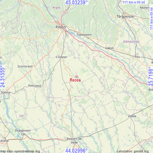
Recea GPS coordinates[2]
44° 31' 59.988" North, 25° 1' 0.012" East
| Map corner | latitude | longitude |
|---|---|---|
| Upper-left | 45.03239°, | 24.31355° |
| Center: | 44.53333°, | 25.01667° |
| Lower-right: | 44.02996°, | 25.7198° |
| Map W x H: | 111.5×111.5 km | = 69.3×69.3mi |
| max Lat: | 48.23793° ⇑84.6% North |
| Recea: | 44.53333° |
| min Lat: | ⇓15.4% South 43.65638° |
| min Long | Recea | max Long |
| 20.31667° | 25.01667° | 29.65403° |
| W 47.6%⇐ | ⇒52.4% E |
Elevation
Elevation of Recea is 167 m = 548 ft, and this is 87.9 m = 288 ft below average elevation for this country.
| Max E: |
1278 m = 4193 ft | 59.8% |
| Avg. | 254.9 m = 836 ft | |
| Recea | 167 m = 548 ft | |
Min E: |
-2 m = -7 ft | 40.2% |
See also: Romania elevation on elevation.city.
Geographical zone
Recea is located in North temperate zone (between Tropic of Cancer and the Arctic Circle). Distance of this Northern Tropic circle is 2345.7 km =1457.5 mi to South.| Distance of | km | miles | from Recea |
|---|---|---|---|
| North Pole | 5055.4 | 3141.3 | to North |
| Arctic Circle | 2449.5 | 1522 | to North |
| Tropic Cancer | 2345.7 | 1457.5 | to South |
| Equator | 4951.6 | 3076.8 | to South |


Nearby cities:
15 places around Recea: (largest is in red/bold)
• Buzoeşti
9.7 km =6 mi,  305°
305°
• Bârlogu
11.5 km =7.1 mi,  26°
26°
• Colțu
8.1 km =5 mi,  237°
237°
• Cornățel
7.1 km =4.4 mi,  316°
316°
• Căldăraru
10.7 km =6.6 mi,  209°
209°
• Deagu de Sus
3.5 km =2.2 mi,  346°
346°
• Găujani
5 km =3.1 mi,  284°
284°
• Humele
3.2 km =2 mi,  255°
255°
• Izvoru
5.8 km =3.6 mi,  138°
138°
• Negraşi
10.8 km =6.7 mi,  46°
46°
• Râca
11.2 km =7 mi,  169°
169°
• Satu Nou
11.7 km =7.3 mi, 242°
• Strâmbeni
7.9 km =4.9 mi, 205°
• Ungheni
5.4 km =3.4 mi,  226°
226°
• Vulpești
9.3 km =5.8 mi, 320°
Sources, notices
• [Note1] Compared only with cities in Romania existing in our database
• [Src1] Map data: © OpenStreetMap contributors (CC-BY-SA)
• [Src2] Other city data from geonames.org with taken over terms of usage.
• [Src3] Geographical zone / Annual Mean Temperature by Robert A. Rohde @ Wikipedia
