Cornățel geodata
Cornățel (Arges) is a populated place; located in Romania in Europe/Bucharest (GMT+3) time zone. With population of 1,112 people, there are 3954 cities with bigger population in this country. Compared to other cities in Romania, 83.4% of cities are located further ↑North; 53.3% of cities are located further →East and 50.1% of cities have higher elevation than Cornățel. Note1


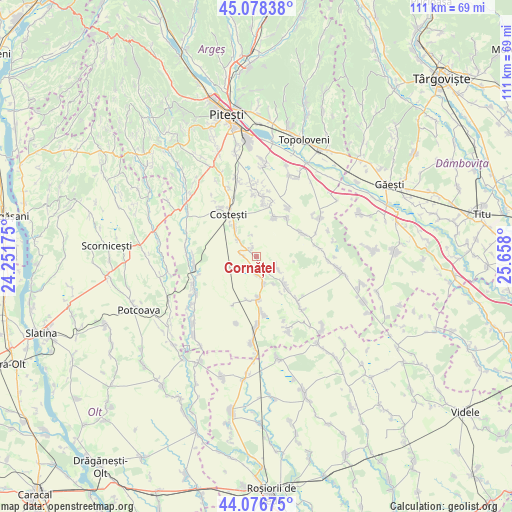
Cornățel GPS coordinates[2]
44° 34' 46.992" North, 24° 57' 17.532" East
| Map corner | latitude | longitude |
|---|---|---|
| Upper-left | 45.07838°, | 24.25175° |
| Center: | 44.57972°, | 24.95487° |
| Lower-right: | 44.07675°, | 25.658° |
| Map W x H: | 111.4×111.4 km | = 69.2×69.2mi |
| max Lat: | 48.23793° ⇑83.4% North |
| Cornățel: | 44.57972° |
| min Lat: | ⇓16.6% South 43.65638° |
| min Long | Cornățel | max Long |
| 20.31667° | 24.95487° | 29.65403° |
| W 46.7%⇐ | ⇒53.3% E |
Elevation
Elevation of Cornățel is 211 m = 692 ft, and this is 43.9 m = 144 ft below average elevation for this country.
| Max E: |
1278 m = 4193 ft | 50.1% |
| Avg. | 254.9 m = 836 ft | |
| Cornățel | 211 m = 692 ft | |
Min E: |
-2 m = -7 ft | 49.9% |
See also: Romania elevation on elevation.city.
Geographical zone
Cornățel is located in North temperate zone (between Tropic of Cancer and the Arctic Circle). Distance of this Northern Tropic circle is 2350.9 km =1460.8 mi to South.| Distance of | km | miles | from Cornățel |
|---|---|---|---|
| North Pole | 5050.3 | 3138.1 | to North |
| Arctic Circle | 2444.4 | 1518.9 | to North |
| Tropic Cancer | 2350.9 | 1460.8 | to South |
| Equator | 4956.8 | 3080 | to South |


Nearby cities:
15 places around Cornățel: (largest is in red/bold)
• Buzoeşti
3.1 km =1.9 mi,  277°
277°
• Bârlogu
11.2 km =7 mi,  62°
62°
• Colțu
9.7 km =6 mi,  191°
191°
• Costeşti
11.2 km =7 mi,  329°
329°
• Deagu de Sus
4.4 km =2.7 mi,  112°
112°
• Gliganu de Jos
10.8 km =6.7 mi,  36°
36°
• Gliganu de Sus
9.5 km =5.9 mi,  23°
23°
• Găujani
3.9 km =2.4 mi,  179°
179°
• Humele
6.2 km =3.9 mi,  163°
163°
• Ionești
5.5 km =3.4 mi,  311°
311°
• Recea
7.1 km =4.4 mi,  136°
136°
• Rociu
11.5 km =7.1 mi,  32°
32°
• Ungheni
8.9 km =5.5 mi,  173°
173°
• Vulpești
2.2 km =1.4 mi, 332°
• Șerboeni
8.1 km =5 mi,  323°
323°
Sources, notices
• [Note1] Compared only with cities in Romania existing in our database
• [Src1] Map data: © OpenStreetMap contributors (CC-BY-SA)
• [Src2] Other city data from geonames.org with taken over terms of usage.
• [Src3] Geographical zone / Annual Mean Temperature by Robert A. Rohde @ Wikipedia
