Bughea de Sus geodata
Bughea de Sus (Arges) is a seat of a second-order administrative division; located in Romania in Europe/Bucharest (GMT+3) time zone. With population of 2,849 people, there are 1876 cities with bigger population in this country. Compared to other cities in Romania, 59% of cities are located further ↑North; 52.2% of cities are located further →East and 94.7% of cities have lower elevation than Bughea de Sus. Note1


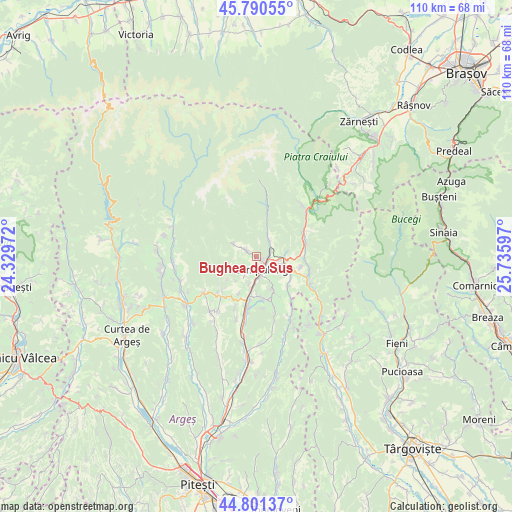
Bughea de Sus GPS coordinates[2]
45° 17' 53.232" North, 25° 1' 58.224" East
| Map corner | latitude | longitude |
|---|---|---|
| Upper-left | 45.79055°, | 24.32972° |
| Center: | 45.29812°, | 25.03284° |
| Lower-right: | 44.80137°, | 25.73597° |
| Map W x H: | 110×110 km | = 68.4×68.4mi |
| max Lat: | 48.23793° ⇑59% North |
| Bughea de Sus: | 45.29812° |
| min Lat: | ⇓41% South 43.65638° |
| min Long | Bughea de Sus | max Long |
| 20.31667° | 25.03284° | 29.65403° |
| W 47.8%⇐ | ⇒52.2% E |
Elevation
Elevation of Bughea de Sus is 618 m = 2028 ft, and this is 363.1 m = 1191 ft above average elevation for this country.
| Max E: |
1278 m = 4193 ft | 5.3% |
| Bughea de Sus | 618 m 2028 ft | |
| Avg. | 254.9 m = 836 ft | |
Min E: |
-2 m = -7 ft | 94.7% |
See also: Romania elevation on elevation.city.
Geographical zone
Bughea de Sus is located in North temperate zone (between Tropic of Cancer and the Arctic Circle). Distance of this North polar circle is 2364.5 km =1469.2 mi to North.| Distance of | km | miles | from Bughea de Sus |
|---|---|---|---|
| North Pole | 4970.4 | 3088.5 | to North |
| Arctic Circle | 2364.5 | 1469.2 | to North |
| Tropic Cancer | 2430.8 | 1510.4 | to South |
| Equator | 5036.7 | 3129.7 | to South |


Nearby cities:
15 places around Bughea de Sus: (largest is in red/bold)
• Albeşti
2.3 km =1.4 mi,  302°
302°
• Bughea de Jos
4.3 km =2.7 mi,  216°
216°
• Câmpulung
3.7 km =2.3 mi,  158°
158°
• Godeni
8.2 km =5.1 mi,  208°
208°
• Groșani
7.8 km =4.8 mi,  179°
179°
• Gura Pravăț
8.1 km =5 mi,  68°
68°
• Gămăcești
9.5 km =5.9 mi,  236°
236°
• Lereşti
4.7 km =2.9 mi,  34°
34°
• Mățău
8 km =5 mi,  150°
150°
• Nămăești
6.4 km =4 mi,  83°
83°
• Piatra
9.8 km =6.1 mi,  103°
103°
• Poienari
9.2 km =5.7 mi,  171°
171°
• Suslănești
9.5 km =5.9 mi,  133°
133°
• Valea Mare Pravăț
4.7 km =2.9 mi, 98°
• Voinești
3.1 km =1.9 mi,  85°
85°
Sources, notices
• [Note1] Compared only with cities in Romania existing in our database
• [Src1] Map data: © OpenStreetMap contributors (CC-BY-SA)
• [Src2] Other city data from geonames.org with taken over terms of usage.
• [Src3] Geographical zone / Annual Mean Temperature by Robert A. Rohde @ Wikipedia
