Deva geodata
Deva (Hunedoara) is a seat of a second-order administrative division; located in Romania in Europe/Bucharest (GMT+3) time zone. With population of 67,802 people, there are 42 cities with bigger population in this country. Compared to other cities in Romania, 52.2% of cities are located further ↓South; 85.9% of cities are located further →East and 53.1% of cities have higher elevation than Deva. Note1


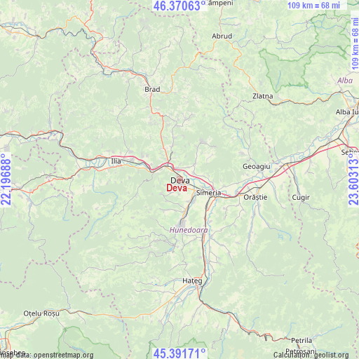
Deva GPS coordinates[2]
45° 52' 59.988" North, 22° 54' 0" East
| Map corner | latitude | longitude |
|---|---|---|
| Upper-left | 46.37063°, | 22.19688° |
| Center: | 45.88333°, | 22.9° |
| Lower-right: | 45.39171°, | 23.60313° |
| Map W x H: | 108.8×108.8 km | = 67.6×67.6mi |
| max Lat: | 48.23793° ⇑47.8% North |
| Deva: | 45.88333° |
| min Lat: | ⇓52.2% South 43.65638° |
| min Long | Deva | max Long |
| 20.31667° | 22.9° | 29.65403° |
| W 14.1%⇐ | ⇒85.9% E |
Elevation
Elevation of Deva is 196 m = 643 ft, and this is 58.9 m = 193 ft below average elevation for this country.
| Max E: |
1278 m = 4193 ft | 53.1% |
| Avg. | 254.9 m = 836 ft | |
| Deva | 196 m = 643 ft | |
Min E: |
-2 m = -7 ft | 46.9% |
See also: Deva elevation on elevation.city.
Geographical zone
Deva is located in North temperate zone (between Tropic of Cancer and the Arctic Circle). Distance of this North polar circle is 2299.4 km =1428.8 mi to North.| Distance of | km | miles | from Deva |
|---|---|---|---|
| North Pole | 4905.3 | 3048 | to North |
| Arctic Circle | 2299.4 | 1428.8 | to North |
| Tropic Cancer | 2495.8 | 1550.8 | to South |
| Equator | 5101.7 | 3170 | to South |


Nearby cities:
15 places around Deva: (largest is in red/bold)
• Banpotoc
8.7 km =5.4 mi,  79°
79°
• Brănişca
9.8 km =6.1 mi,  292°
292°
• Bârsău
7 km =4.3 mi,  42°
42°
• Certeju de Sus
10.6 km =6.6 mi,  29°
29°
• Cristur
6.9 km =4.3 mi,  150°
150°
• Cârjiţi
6.4 km =4 mi,  234°
234°
• Hărău
4.3 km =2.7 mi,  64°
64°
• Mintia
6 km =3.7 mi,  318°
318°
• Peştişu Mic
9.4 km =5.8 mi,  187°
187°
• Peștișu Mare
9.3 km =5.8 mi,  166°
166°
• Simeria
9.8 km =6.1 mi,  112°
112°
• Sântandrei
6.4 km =4 mi,  125°
125°
• Sântuhalm
5.1 km =3.2 mi,  124°
124°
• Veţel
6.7 km =4.2 mi, 286°
• Şoimuş
3.7 km =2.3 mi,  0°
0°
Sources, notices
• [Note1] Compared only with cities in Romania existing in our database
• [Src1] Map data: © OpenStreetMap contributors (CC-BY-SA)
• [Src2] Other city data from geonames.org with taken over terms of usage.
• [Src3] Geographical zone / Annual Mean Temperature by Robert A. Rohde @ Wikipedia
