Cristur geodata
Cristur (Hunedoara) is a populated place; located in Romania in Europe/Bucharest (GMT+3) time zone. With population of 1,376 people, there are 3382 cities with bigger population in this country. Compared to other cities in Romania, 51% of cities are located further ↓South; 85.3% of cities are located further →East and 51.8% of cities have higher elevation than Cristur. Note1


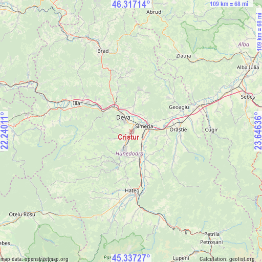
Cristur GPS coordinates[2]
45° 49' 45.696" North, 22° 56' 35.628" East
| Map corner | latitude | longitude |
|---|---|---|
| Upper-left | 46.31714°, | 22.24011° |
| Center: | 45.82936°, | 22.94323° |
| Lower-right: | 45.33727°, | 23.64636° |
| Map W x H: | 109×109 km | = 67.7×67.7mi |
| max Lat: | 48.23793° ⇑49% North |
| Cristur: | 45.82936° |
| min Lat: | ⇓51% South 43.65638° |
| min Long | Cristur | max Long |
| 20.31667° | 22.94323° | 29.65403° |
| W 14.7%⇐ | ⇒85.3% E |
Elevation
Elevation of Cristur is 202 m = 663 ft, and this is 52.9 m = 174 ft below average elevation for this country.
| Max E: |
1278 m = 4193 ft | 51.8% |
| Avg. | 254.9 m = 836 ft | |
| Cristur | 202 m = 663 ft | |
Min E: |
-2 m = -7 ft | 48.2% |
See also: Romania elevation on elevation.city.
Geographical zone
Cristur is located in North temperate zone (between Tropic of Cancer and the Arctic Circle). Distance of this North polar circle is 2305.4 km =1432.5 mi to North.| Distance of | km | miles | from Cristur |
|---|---|---|---|
| North Pole | 4911.3 | 3051.7 | to North |
| Arctic Circle | 2305.4 | 1432.5 | to North |
| Tropic Cancer | 2489.8 | 1547.1 | to South |
| Equator | 5095.7 | 3166.3 | to South |


Nearby cities:
15 places around Cristur: (largest is in red/bold)
• Banpotoc
9.2 km =5.7 mi,  34°
34°
• Batiz
7.3 km =4.5 mi,  141°
141°
• Băcia
6.6 km =4.1 mi,  119°
119°
• Cârjiţi
8.8 km =5.5 mi,  285°
285°
• Deva
6.9 km =4.3 mi,  330°
330°
• Hunedoara
9.4 km =5.8 mi,  200°
200°
• Hărău
7.9 km =4.9 mi,  3°
3°
• Petreni
7.7 km =4.8 mi, 122°
• Peştişu Mic
5.7 km =3.5 mi,  234°
234°
• Peștișu Mare
3.3 km =2.1 mi, 202°
• Răcăștia
8.7 km =5.4 mi,  218°
218°
• Simeria
6.1 km =3.8 mi,  68°
68°
• Sântandrei
2.9 km =1.8 mi,  38°
38°
• Sântuhalm
3.2 km =2 mi,  14°
14°
• Tâmpa
5.6 km =3.5 mi,  94°
94°
Sources, notices
• [Note1] Compared only with cities in Romania existing in our database
• [Src1] Map data: © OpenStreetMap contributors (CC-BY-SA)
• [Src2] Other city data from geonames.org with taken over terms of usage.
• [Src3] Geographical zone / Annual Mean Temperature by Robert A. Rohde @ Wikipedia
