Cucuteni geodata
Cucuteni (Iaşi) is a seat of a second-order administrative division; located in Romania in Europe/Bucharest (GMT+3) time zone. With population of 1,454 people, there are 3252 cities with bigger population in this country. Compared to other cities in Romania, 86.1% of cities are located further ↓South; 81.8% of cities are located further ←West and 63.6% of cities have lower elevation than Cucuteni. Note1


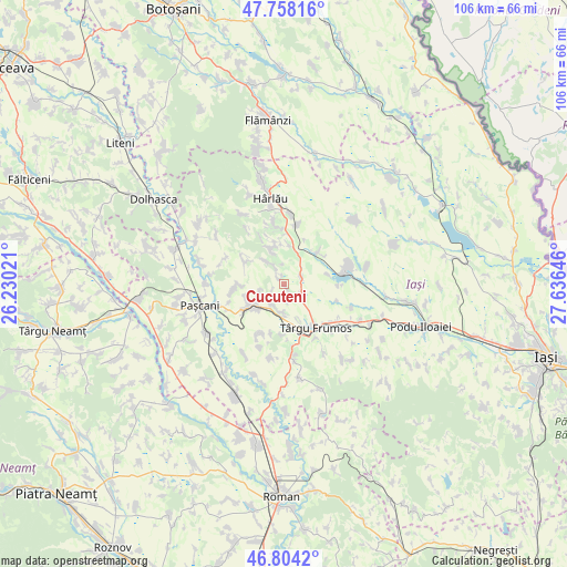
Cucuteni GPS coordinates[2]
47° 16' 59.988" North, 26° 55' 59.988" East
| Map corner | latitude | longitude |
|---|---|---|
| Upper-left | 47.75816°, | 26.23021° |
| Center: | 47.28333°, | 26.93333° |
| Lower-right: | 46.8042°, | 27.63646° |
| Map W x H: | 106.1×106.1 km | = 65.9×65.9mi |
| max Lat: | 48.23793° ⇑13.9% North |
| Cucuteni: | 47.28333° |
| min Lat: | ⇓86.1% South 43.65638° |
| min Long | Cucuteni | max Long |
| 20.31667° | 26.93333° | 29.65403° |
| W 81.8%⇐ | ⇒18.2% E |
Elevation
Elevation of Cucuteni is 282 m = 925 ft, and this is 27.1 m = 89 ft above average elevation for this country.
| Max E: |
1278 m = 4193 ft | 36.4% |
| Cucuteni | 282 m 925 ft | |
| Avg. | 254.9 m = 836 ft | |
Min E: |
-2 m = -7 ft | 63.6% |
See also: Romania elevation on elevation.city.
Geographical zone
Cucuteni is located in North temperate zone (between Tropic of Cancer and the Arctic Circle). Distance of this North polar circle is 2143.8 km =1332.1 mi to North.| Distance of | km | miles | from Cucuteni |
|---|---|---|---|
| North Pole | 4749.6 | 2951.3 | to North |
| Arctic Circle | 2143.8 | 1332.1 | to North |
| Tropic Cancer | 2651.5 | 1647.6 | to South |
| Equator | 5257.4 | 3266.8 | to South |


Nearby cities:
15 places around Cucuteni: (largest is in red/bold)
• Balș
3.7 km =2.3 mi,  67°
67°
• Boureni
3.9 km =2.4 mi,  121°
121°
• Costești
5.5 km =3.4 mi,  185°
185°
• Cotnari
8.3 km =5.2 mi,  26°
26°
• Cârjoaia
6.6 km =4.1 mi,  343°
343°
• Dumbrăvița
7.6 km =4.7 mi,  245°
245°
• Giurgești
4.1 km =2.5 mi,  206°
206°
• Heleșteni
9.9 km =6.2 mi, 205°
• Hodora
8.8 km =5.5 mi,  47°
47°
• Horodiștea
8 km =5 mi,  347°
347°
• Hărmăneștii Vechi
9 km =5.6 mi,  265°
265°
• Liteni
8.2 km =5.1 mi,  75°
75°
• Rediu
7.1 km =4.4 mi,  227°
227°
• Ruginoasa
7.3 km =4.5 mi,  239°
239°
• Todireşti
8.4 km =5.2 mi,  296°
296°
Sources, notices
• [Note1] Compared only with cities in Romania existing in our database
• [Src1] Map data: © OpenStreetMap contributors (CC-BY-SA)
• [Src2] Other city data from geonames.org with taken over terms of usage.
• [Src3] Geographical zone / Annual Mean Temperature by Robert A. Rohde @ Wikipedia
