Batiz geodata
Batiz (Hunedoara) is a populated place; located in Romania in Europe/Bucharest (GMT+3) time zone. With population of 604 people, there are 6177 cities with bigger population in this country. Compared to other cities in Romania, 50.3% of cities are located further ↑North; 84.4% of cities are located further →East and 50.8% of cities have lower elevation than Batiz. Note1


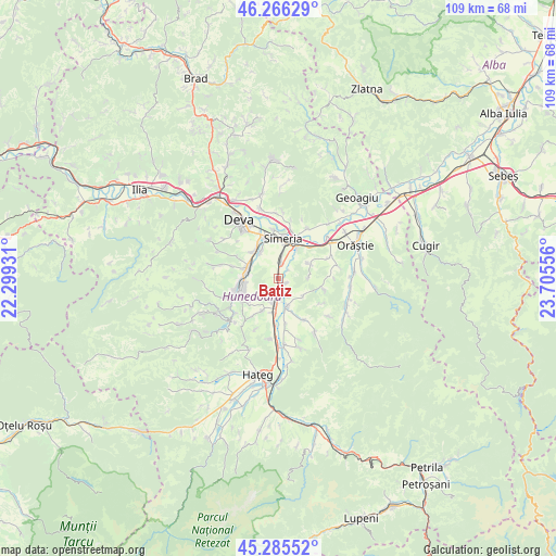
Batiz GPS coordinates[2]
45° 46' 41.016" North, 23° 0' 8.748" East
| Map corner | latitude | longitude |
|---|---|---|
| Upper-left | 46.26629°, | 22.29931° |
| Center: | 45.77806°, | 23.00243° |
| Lower-right: | 45.28552°, | 23.70556° |
| Map W x H: | 109.1×109.1 km | = 67.8×67.8mi |
| max Lat: | 48.23793° ⇑50.3% North |
| Batiz: | 45.77806° |
| min Lat: | ⇓49.7% South 43.65638° |
| min Long | Batiz | max Long |
| 20.31667° | 23.00243° | 29.65403° |
| W 15.6%⇐ | ⇒84.4% E |
Elevation
Elevation of Batiz is 216 m = 709 ft, and this is 38.9 m = 128 ft below average elevation for this country.
| Max E: |
1278 m = 4193 ft | 49.2% |
| Avg. | 254.9 m = 836 ft | |
| Batiz | 216 m = 709 ft | |
Min E: |
-2 m = -7 ft | 50.8% |
See also: Romania elevation on elevation.city.
Geographical zone
Batiz is located in North temperate zone (between Tropic of Cancer and the Arctic Circle). Distance of this North polar circle is 2311.1 km =1436.1 mi to North.| Distance of | km | miles | from Batiz |
|---|---|---|---|
| North Pole | 4917 | 3055.3 | to North |
| Arctic Circle | 2311.1 | 1436.1 | to North |
| Tropic Cancer | 2484.1 | 1543.5 | to South |
| Equator | 5090 | 3162.8 | to South |


Nearby cities:
15 places around Batiz: (largest is in red/bold)
• Băcia
2.7 km =1.7 mi,  24°
24°
• Chitid
9.5 km =5.9 mi,  148°
148°
• Cristur
7.3 km =4.5 mi,  321°
321°
• Călan
5.2 km =3.2 mi,  196°
196°
• Hunedoara
8.5 km =5.3 mi,  248°
248°
• Petreni
2.5 km =1.6 mi,  49°
49°
• Peştişu Mic
9.6 km =6 mi,  284°
284°
• Peștișu Mare
6.4 km =4 mi,  294°
294°
• Rapoltu Mare
11 km =6.8 mi,  26°
26°
• Răcăștia
10.1 km =6.3 mi,  263°
263°
• Simeria
8.1 km =5 mi,  7°
7°
• Streisângeorgiu
5.8 km =3.6 mi,  164°
164°
• Sântandrei
8.5 km =5.3 mi,  340°
340°
• Sântuhalm
9.6 km =6 mi, 336°
• Tâmpa
5.4 km =3.4 mi, 10°
Sources, notices
• [Note1] Compared only with cities in Romania existing in our database
• [Src1] Map data: © OpenStreetMap contributors (CC-BY-SA)
• [Src2] Other city data from geonames.org with taken over terms of usage.
• [Src3] Geographical zone / Annual Mean Temperature by Robert A. Rohde @ Wikipedia
