Costești geodata
Costești (Hunedoara) is a populated place; located in Romania in Europe/Bucharest (GMT+3) time zone. With population of 535 people, there are 6723 cities with bigger population in this country. Compared to other cities in Romania, 51.9% of cities are located further ↑North; 82.1% of cities are located further →East and 76.9% of cities have lower elevation than Costești. Note1


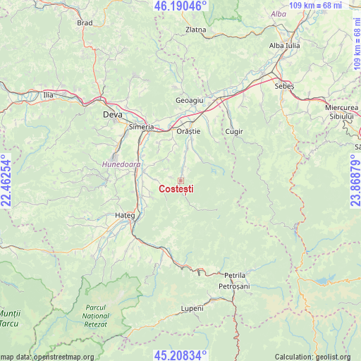
Costești GPS coordinates[2]
45° 42' 5.616" North, 23° 9' 56.376" East
| Map corner | latitude | longitude |
|---|---|---|
| Upper-left | 46.19046°, | 22.46254° |
| Center: | 45.70156°, | 23.16566° |
| Lower-right: | 45.20834°, | 23.86879° |
| Map W x H: | 109.2×109.2 km | = 67.9×67.9mi |
| max Lat: | 48.23793° ⇑51.9% North |
| Costești: | 45.70156° |
| min Lat: | ⇓48.1% South 43.65638° |
| min Long | Costești | max Long |
| 20.31667° | 23.16566° | 29.65403° |
| W 17.9%⇐ | ⇒82.1% E |
Elevation
Elevation of Costești is 367 m = 1204 ft, and this is 112.1 m = 368 ft above average elevation for this country.
| Max E: |
1278 m = 4193 ft | 23.1% |
| Costești | 367 m 1204 ft | |
| Avg. | 254.9 m = 836 ft | |
Min E: |
-2 m = -7 ft | 76.9% |
See also: Romania elevation on elevation.city.
Geographical zone
Costești is located in North temperate zone (between Tropic of Cancer and the Arctic Circle). Distance of this North polar circle is 2319.6 km =1441.3 mi to North.| Distance of | km | miles | from Costești |
|---|---|---|---|
| North Pole | 4925.5 | 3060.6 | to North |
| Arctic Circle | 2319.6 | 1441.3 | to North |
| Tropic Cancer | 2475.6 | 1538.3 | to South |
| Equator | 5081.5 | 3157.5 | to South |


Nearby cities:
15 places around Costești: (largest is in red/bold)
• Batiz
15.3 km =9.5 mi,  303°
303°
• Beriu
9.2 km =5.7 mi,  8°
8°
• Boşorod
6.7 km =4.2 mi,  252°
252°
• Bretea Română
12.4 km =7.7 mi, 248°
• Băcia
15.9 km =9.9 mi,  313°
313°
• Chitid
7.7 km =4.8 mi,  273°
273°
• Călan
14.6 km =9.1 mi,  284°
284°
• Căstău
13.1 km =8.1 mi,  15°
15°
• Mărtineşti
13 km =8.1 mi,  348°
348°
• Orăştie
14.9 km =9.3 mi, 10°
• Orăştioara de Sus
3.5 km =2.2 mi,  1°
1°
• Petreni
14.8 km =9.2 mi, 313°
• Romoșel
16.2 km =10.1 mi,  44°
44°
• Sibișel
8.5 km =5.3 mi,  50°
50°
• Streisângeorgiu
11.5 km =7.1 mi, 284°
Sources, notices
• [Note1] Compared only with cities in Romania existing in our database
• [Src1] Map data: © OpenStreetMap contributors (CC-BY-SA)
• [Src2] Other city data from geonames.org with taken over terms of usage.
• [Src3] Geographical zone / Annual Mean Temperature by Robert A. Rohde @ Wikipedia
