Boşorod geodata
Boşorod (Hunedoara) is a seat of a second-order administrative division; located in Romania in Europe/Bucharest (GMT+3) time zone. With population of 2,224 people, there are 2398 cities with bigger population in this country. Compared to other cities in Romania, 52.4% of cities are located further ↑North; 83.3% of cities are located further →East and 68.6% of cities have lower elevation than Boşorod. Note1


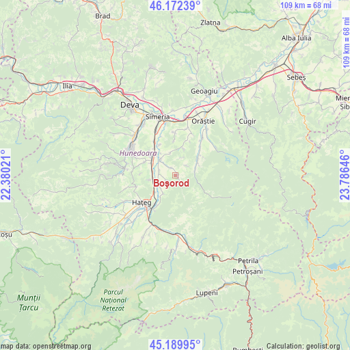
Boşorod GPS coordinates[2]
45° 40' 59.988" North, 23° 4' 59.988" East
| Map corner | latitude | longitude |
|---|---|---|
| Upper-left | 46.17239°, | 22.38021° |
| Center: | 45.68333°, | 23.08333° |
| Lower-right: | 45.18995°, | 23.78646° |
| Map W x H: | 109.2×109.2 km | = 67.9×67.9mi |
| max Lat: | 48.23793° ⇑52.4% North |
| Boşorod: | 45.68333° |
| min Lat: | ⇓47.6% South 43.65638° |
| min Long | Boşorod | max Long |
| 20.31667° | 23.08333° | 29.65403° |
| W 16.7%⇐ | ⇒83.3% E |
Elevation
Elevation of Boşorod is 310 m = 1017 ft, and this is 55.1 m = 181 ft above average elevation for this country.
| Max E: |
1278 m = 4193 ft | 31.4% |
| Boşorod | 310 m 1017 ft | |
| Avg. | 254.9 m = 836 ft | |
Min E: |
-2 m = -7 ft | 68.6% |
See also: Romania elevation on elevation.city.
Geographical zone
Boşorod is located in North temperate zone (between Tropic of Cancer and the Arctic Circle). Distance of this North polar circle is 2321.7 km =1442.6 mi to North.| Distance of | km | miles | from Boşorod |
|---|---|---|---|
| North Pole | 4927.6 | 3061.9 | to North |
| Arctic Circle | 2321.7 | 1442.6 | to North |
| Tropic Cancer | 2473.6 | 1537 | to South |
| Equator | 5079.5 | 3156.3 | to South |


Nearby cities:
15 places around Boşorod: (largest is in red/bold)
• Batiz
12.3 km =7.6 mi,  329°
329°
• Beriu
13.6 km =8.5 mi,  34°
34°
• Bretea Română
5.7 km =3.5 mi,  243°
243°
• Bucium-Orlea
14.3 km =8.9 mi,  219°
219°
• Băcia
14 km =8.7 mi,  338°
338°
• Chitid
2.8 km =1.7 mi, 332°
• Costești
6.7 km =4.2 mi,  72°
72°
• Călan
9.5 km =5.9 mi,  305°
305°
• Haţeg
12.7 km =7.9 mi,  234°
234°
• Orăştioara de Sus
8.5 km =5.3 mi,  49°
49°
• Petreni
12.9 km =8 mi, 340°
• Sibișel
14.9 km =9.3 mi,  60°
60°
• Streisângeorgiu
6.8 km =4.2 mi,  316°
316°
• Subcetate
11.1 km =6.9 mi, 216°
• Sântămăria-Orlea
13.7 km =8.5 mi, 219°
Sources, notices
• [Note1] Compared only with cities in Romania existing in our database
• [Src1] Map data: © OpenStreetMap contributors (CC-BY-SA)
• [Src2] Other city data from geonames.org with taken over terms of usage.
• [Src3] Geographical zone / Annual Mean Temperature by Robert A. Rohde @ Wikipedia
