Colacu geodata
Colacu (Suceava) is a section of populated place; located in Romania in Europe/Bucharest (GMT+3) time zone. With population of 1,047 people, there are 4133 cities with bigger population in this country. Compared to other cities in Romania, 91.8% of cities are located further ↓South; 52.2% of cities are located further ←West and 97.8% of cities have lower elevation than Colacu. Note1


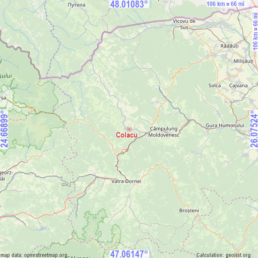
Colacu GPS coordinates[2]
47° 32' 17.88" North, 25° 22' 19.596" East
| Map corner | latitude | longitude |
|---|---|---|
| Upper-left | 48.01083°, | 24.66899° |
| Center: | 47.5383°, | 25.37211° |
| Lower-right: | 47.06147°, | 26.07524° |
| Map W x H: | 105.6×105.6 km | = 65.6×65.6mi |
| max Lat: | 48.23793° ⇑8.2% North |
| Colacu: | 47.5383° |
| min Lat: | ⇓91.8% South 43.65638° |
| min Long | Colacu | max Long |
| 20.31667° | 25.37211° | 29.65403° |
| W 52.2%⇐ | ⇒47.8% E |
Elevation
Elevation of Colacu is 757 m = 2484 ft, and this is 502.1 m = 1647 ft above average elevation for this country.
| Max E: |
1278 m = 4193 ft | 2.2% |
| Colacu | 757 m 2484 ft | |
| Avg. | 254.9 m = 836 ft | |
Min E: |
-2 m = -7 ft | 97.8% |
See also: Romania elevation on elevation.city.
Geographical zone
Colacu is located in North temperate zone (between Tropic of Cancer and the Arctic Circle). Distance of this North polar circle is 2115.4 km =1314.4 mi to North.| Distance of | km | miles | from Colacu |
|---|---|---|---|
| North Pole | 4721.3 | 2933.7 | to North |
| Arctic Circle | 2115.4 | 1314.4 | to North |
| Tropic Cancer | 2679.8 | 1665.2 | to South |
| Equator | 5285.8 | 3284.4 | to South |


Nearby cities:
15 places around Colacu: (largest is in red/bold)
• Argestru
17.8 km =11.1 mi,  191°
191°
• Benia
16.1 km =10 mi,  330°
330°
• Botuș
3.3 km =2.1 mi,  316°
316°
• Breaza
9.4 km =5.8 mi, 334°
• Ciocănești
9.4 km =5.8 mi,  227°
227°
• Câmpulung Moldovenesc
14.6 km =9.1 mi,  92°
92°
• Cârlibaba
18.6 km =11.6 mi,  285°
285°
• Deia
19.6 km =12.2 mi,  71°
71°
• Fundu Moldovei
2.2 km =1.4 mi,  104°
104°
• Iacobeni
12.4 km =7.7 mi,  199°
199°
• Moldova Suliţa
18.5 km =11.5 mi, 330°
• Moldoviţa
20.2 km =12.6 mi,  36°
36°
• Pojorâta
6.3 km =3.9 mi,  112°
112°
• Sadova
9.6 km =6 mi, 93°
• Vatra Moldoviţei
19.2 km =11.9 mi,  49°
49°
Sources, notices
• [Note1] Compared only with cities in Romania existing in our database
• [Src1] Map data: © OpenStreetMap contributors (CC-BY-SA)
• [Src2] Other city data from geonames.org with taken over terms of usage.
• [Src3] Geographical zone / Annual Mean Temperature by Robert A. Rohde @ Wikipedia
