Catanele geodata
Catanele (Olt) is a populated place; located in Romania in Europe/Bucharest (GMT+3) time zone. With population of 1,050 people, there are 4124 cities with bigger population in this country. Compared to other cities in Romania, 88.8% of cities are located further ↑North; 59.4% of cities are located further →East and 63.9% of cities have higher elevation than Catanele. Note1


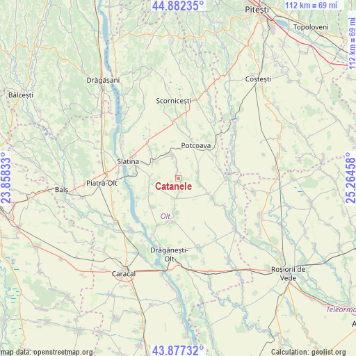
Catanele GPS coordinates[2]
44° 22' 55.164" North, 24° 33' 41.22" East
| Map corner | latitude | longitude |
|---|---|---|
| Upper-left | 44.88235°, | 23.85833° |
| Center: | 44.38199°, | 24.56145° |
| Lower-right: | 43.87732°, | 25.26458° |
| Map W x H: | 111.7×111.7 km | = 69.4×69.4mi |
| max Lat: | 48.23793° ⇑88.8% North |
| Catanele: | 44.38199° |
| min Lat: | ⇓11.2% South 43.65638° |
| min Long | Catanele | max Long |
| 20.31667° | 24.56145° | 29.65403° |
| W 40.6%⇐ | ⇒59.4% E |
Elevation
Elevation of Catanele is 151 m = 495 ft, and this is 103.9 m = 341 ft below average elevation for this country.
| Max E: |
1278 m = 4193 ft | 63.9% |
| Avg. | 254.9 m = 836 ft | |
| Catanele | 151 m = 495 ft | |
Min E: |
-2 m = -7 ft | 36.1% |
See also: Romania elevation on elevation.city.
Geographical zone
Catanele is located in North temperate zone (between Tropic of Cancer and the Arctic Circle). Distance of this Northern Tropic circle is 2328.9 km =1447.1 mi to South.| Distance of | km | miles | from Catanele |
|---|---|---|---|
| North Pole | 5072.2 | 3151.7 | to North |
| Arctic Circle | 2466.4 | 1532.5 | to North |
| Tropic Cancer | 2328.9 | 1447.1 | to South |
| Equator | 4934.8 | 3066.3 | to South |


Nearby cities:
15 places around Catanele: (largest is in red/bold)
• Bacea
6.3 km =3.9 mi,  73°
73°
• Brebeni
9 km =5.6 mi,  259°
259°
• Bălteni
7.8 km =4.8 mi,  342°
342°
• Bărcănești
9.1 km =5.7 mi,  187°
187°
• Greci
5.8 km =3.6 mi,  181°
181°
• Lisa
4 km =2.5 mi,  214°
214°
• Mierleștii de Sus
2.7 km =1.7 mi,  356°
356°
• Movileni
7.2 km =4.5 mi,  103°
103°
• Măgura
1.4 km =0.9 mi, 338°
• Perieţi
2.2 km =1.4 mi, 335°
• Schitu
3.6 km =2.2 mi,  173°
173°
• Turia
9.8 km =6.1 mi,  317°
317°
• Vâlcele
11.1 km =6.9 mi, 187°
• Vâlcelele de Sus
10.8 km =6.7 mi, 181°
• Șerbăneștii de Sus
10.9 km =6.8 mi,  117°
117°
Sources, notices
• [Note1] Compared only with cities in Romania existing in our database
• [Src1] Map data: © OpenStreetMap contributors (CC-BY-SA)
• [Src2] Other city data from geonames.org with taken over terms of usage.
• [Src3] Geographical zone / Annual Mean Temperature by Robert A. Rohde @ Wikipedia
