Ruma geodata
Ruma (Vojvodina) is a seat of a third-order administrative division; located in Serbia in Europe/Belgrade (GMT+2) time zone. With population of 32,229 people, there are 28 cities with bigger population in this country. Compared to other cities in Serbia, 58% of cities are located further ↓South; 72.3% of cities are located further →East and 61.2% of cities have lower elevation than Ruma. Note1


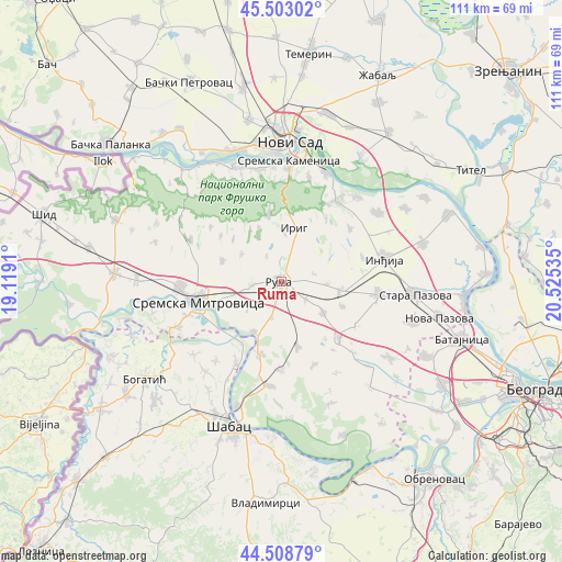
Ruma GPS coordinates[2]
45° 0' 29.016" North, 19° 49' 19.992" East
| Map corner | latitude | longitude |
|---|---|---|
| Upper-left | 45.50302°, | 19.1191° |
| Center: | 45.00806°, | 19.82222° |
| Lower-right: | 44.50879°, | 20.52535° |
| Map W x H: | 110.5×110.5 km | = 68.7×68.7mi |
| max Lat: | 46.1° ⇑42% North |
| Ruma: | 45.00806° |
| min Lat: | ⇓58% South 42.25846° |
| min Long | Ruma | max Long |
| 18.9276° | 19.82222° | 22.77556° |
| W 27.7%⇐ | ⇒72.3% E |
Elevation
Elevation of Ruma is 114 m = 374 ft, and this is 62.4 m = 205 ft below average elevation for this country.
| Max E: |
1421 m = 4662 ft | 38.8% |
| Avg. | 176.4 m = 579 ft | |
| Ruma | 114 m = 374 ft | |
Min E: |
49 m = 161 ft | 61.2% |
See also: Serbia elevation on elevation.city.
Geographical zone
Ruma is located in North temperate zone (between Tropic of Cancer and the Arctic Circle). Distance of this North polar circle is 2396.7 km =1489.2 mi to North.| Distance of | km | miles | from Ruma |
|---|---|---|---|
| North Pole | 5002.6 | 3108.5 | to North |
| Arctic Circle | 2396.7 | 1489.2 | to North |
| Tropic Cancer | 2398.5 | 1490.4 | to South |
| Equator | 5004.4 | 3109.6 | to South |


Nearby cities:
15 places around Ruma: (largest is in red/bold)
• Buđanovci
13.1 km =8.1 mi,  165°
165°
• Drenovac
18.1 km =11.2 mi,  209°
209°
• Golubinci
19.1 km =11.9 mi,  97°
97°
• Hrtkovci
14.8 km =9.2 mi,  198°
198°
• Irig
5.2 km =3.2 mi,  19°
19°
• Irig
10.7 km =6.6 mi, 15°
• Jarak
11.3 km =7 mi, 208°
• Ljukovo
16.2 km =10.1 mi,  82°
82°
• Mačvanska Mitrovica
18.6 km =11.6 mi,  255°
255°
• Nikinci
17.6 km =10.9 mi,  179°
179°
• Pećinci
15.8 km =9.8 mi,  134°
134°
• Putinci
11.8 km =7.3 mi, 98°
• Sremska Mitrovica
16.9 km =10.5 mi, 257°
• Vrdnik
12.9 km =8 mi,  349°
349°
• Šašinci
7.9 km =4.9 mi,  233°
233°
Sources, notices
• [Note1] Compared only with cities in Serbia existing in our database
• [Src1] Map data: © OpenStreetMap contributors (CC-BY-SA)
• [Src2] Other city data from geonames.org with taken over terms of usage.
• [Src3] Geographical zone / Annual Mean Temperature by Robert A. Rohde @ Wikipedia
